NATURE | | | You are in: Southampton > Nature > Walks > Netley Shoreline>Information | | 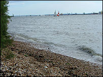
Explore the natural history of Southampton Water |
Follow this walk round the Royal Victoria Country Park at Netley to discover some of the natural history surrounding Southampton Water and find out about the amazing story of our coastline.
Start the walk now>> | | | | Walk details: | | Start point: | Tea Rooms at the Royal Victoria Country Park, Netley | | Countryside Rangers' office: | 023 8045 5157 | | Ordnance Survey: | Landranger: 196 Solent & Isle of Wight (SU 464076)
Explorer: Hamble Common - 119, Royal Victoria Country Park - Outdoor Leisure map 22 | | Distance: | approx 2km (1.2 miles) | | Time: | approx 1 hour (The walk can be extended by approx 4 km/1.5 hours to include Hamble Common) | Extra info:
To see what the symbols mean, please visit the key |       
    | |
| | More info:
This walk takes you on a journey to discover how a frozen wasteland was transformed into one of the most familiar parts of our coastline. Find out more about the bird and plant life living alongside one of our busiest ports and waterways.
| Getting there:
By train: Netley station is on the main Southampton to Portsmouth line. The back entrance to the park is a 5-10 minute walk from the station. Follow the signs outside the station carpark. Get the latest rail information.
By Bus: Bus no 16 goes to Netley Village from Southampton. From the village, follow the brown tourist road signs into the park via the main entrance along the coast road. For more details, please contact First Bus tel 023 8022 4854.
On Foot: Pedestrian access points, other than those described above, are available via the Solent Way and the Hamble Rail Trail.
By car: Follow the brown tourist signs for the Royal Victoria Country Park from junction 8 off the M27 or A27. Parking is available (£1.10 Mon-Sat/£1.60 on Sundays). Parking is free for orange badge holders. Get the latest online road information. | | Walk conditionsHealth and Safety information
Paths are mainly tarmac. There are steps down to the beach, or alternatively use the slipway. The beach is mainly shingle and stones and may be difficult for buggies or wheelchairs - within the park, a tarmac path runs along the foreshore, very close to the beach and can be used as an alternative. The beach is most accessible at lowtide - check the tide times to find when the most suitable time to do this walk is.
Walk designed by Phil Halliwell, Hampshire County Council
Open University Consultant - Tony Cross | | | You are in: Southampton > Nature > Walks > Netley Shoreline> Introduction | |
 | | 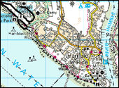 |  Enlarge map. © Crown copyright. All rights reserved. BBC licence number 100019855, 2004. Map not reproduced to scale. Enlarge map. © Crown copyright. All rights reserved. BBC licence number 100019855, 2004. Map not reproduced to scale. | | | | | SEE ALSO | | On bbc.co.ukRest of the webThe BBC is not responsible for the content of external websites | |  |  | | More walks through time and amazing wildlife. |
|  |  | Get more from your walk,
with the Open University. |
|
| BBC Southampton website, Broadcasting House, Havelock Road, Southampton SO14 7PU
phone: 023 8063 1311 | e-mail: [email protected] | |
|