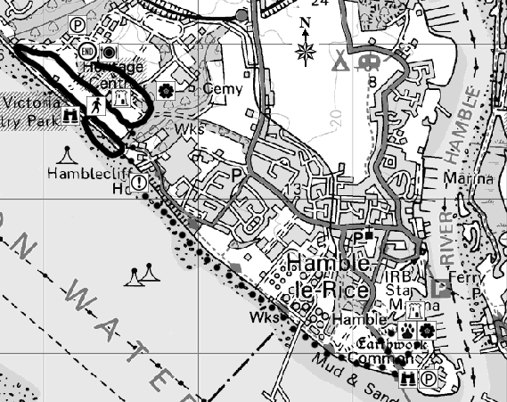
Start Point: Royal Victoria County Park's Visitor Centre, Netley
Countryside Rangers Office:023 8045 5157
Ordnance Survey:Landranger: 196 Solent & Isle of Wight (SU 464076)
Explorer: Hamble Common - 119, Royal Victoria Country Park - Outdoor Leisure map 22
Distance: approx 2km (1.2 miles)
Time: approx 1 hour
Walk Conditions:
Paths in the Country Park are mainly tarmac. There are steps down to the beach, or alternatively use the slipway. The beach is mainly shingle and stones and may be difficult for buggies or wheelchairs - a tarmac path runs along the foreshore, very close to the beach and can be used as an alternative. The beach is most accessible at lowtide - check the tide times to find when the most suitable time to do this walk is.
You are overlooking Southampton Water, Fawley and the New Forest are directly infront of you, with the Isle of Wight away to your left.
The Solent is the drowned valley of a great river which once flowed east between what are now the Isle of Wight When the Ice Age ended and the ice retreated 20,000 years ago, sea levels rose creating the familiar coastline we know today.
As the ice melted, sediment was deposited in the shallow, sheltered waters and river estuaries which created mud and sand flats, the higher parts of which have been colonised by salt marsh vegetation.
From the Bronze Age hunter-gatherers, through Gaul, Roman and Germanic invasions and medieval times, people began to tame the environment and there is evidence of fishing, oyster catching and salt making.
Look out for oyster shells on the beach, as well as clams. If the tide is out, you'll see birds searching for food in the mud. Up to 80,000 invertebrates could be living in a single square metre of mud. No wonder it's such a popular refueling station for migrating birds on their way to places like Iceland and Scandinavia.
You will notice part of the seawall is closed to the public. This illustrates one of the greatest contemporary challenges posed by the natural environment - coastal erosion.
Some erosion is a natural process - material is removed from one coastline by the sea, and deposited elsewhere in sandbars and mudflats. But add to that the effects of climate change, pollution and the pressure on coastal areas is huge.
This chapel was the centre of the vast military hospital opened in 1856. It was once the biggest building in Europe and was where soldiers from the Crimea, 1914-18 and the D-Day landings were treated.
It stands at 50 metres high - but within 18,000 years the sea levels could have risen by 60 metres. This is mostly due to movements in the earth's crust as it recovers from the Ice Age when the weight of ice forced the land mass downwards.
On your way you can see some of the birdlife which uses the food-rich mud of Southampton Water to re-fuel. It's an important habitat for oystercatchers, teal and brent geese.
Hamble Common is the site of some of the earliest evidence of settlement in Hampshire. The ditch and bank running right across the site probably protected an Iron Age settlement, from around 500BC. Look out for the Bell heather and purple moor-grass.
Look around at the different species of tree - and if it's springtime, enjoy the carpet of bluebells. Britain is unique in Europe for its large old trees and for its bluebell woods. Woodland covered most of Britain until stone age and iron age man started to cut it to use the land for farming.
The strong English oak was very important for ship building - a major industry in the Solent area.
Our wildlife has changed over the years as well - bear, wolf, beaver were all hunted to extinction. The grey squirrel, which was introduced from North America in the 19th Century has replaced our native red, except for isolated regions like the Isle of Wight. Alien species such as rhododendron and Japanese knotweed are spreading to the detriment of our native wildlife.