13 November 2014 |

| |
BBC Homepage | |||
Contact Us | |||
Nature FeaturesYou are in: Somerset > Nature > Nature Features > Coleridge Way 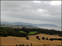 Coleridge WayThe Coleridge Way is 36 miles long and runs from Nether Stowey to Porlock but if that sounds like too much hard work, you can do shorter sections of it, along the most scenic parts of the route.
The Coleridge Way is a very long walk and is best done over the space of a few days. If you don't have time, you can cheat and walk shorter sections of the route and still get plenty of enjoyment out of it with views of the Somerset coastline as far as Minehead. This section was roughly four miles long and took about three hours to complete because it is hilly in places and some of the paths are muddy and rocky. Taking you on this tour is Heidi Morse from West Quantoxhead who was involved in setting up the trail. Holford to West QuantoxheadStart at Holford Green car park Walk towards the old dog pound, and go uphill along the main road which leads to Alfoxton Park Walk through the grounds, along the main house, following the main path. There are views on the right of Hinkley Point power station This main path leads onto the Quantock Hills along the Quantock Greenway for about three miles Along this path there are views of Flatholme and Steepholme and as the path drops down into West Quantoxhead, there are views of St Audrey's Park Follow the signposted route, which leads into the outskirts of West Quantoxhead last updated: 04/03/2009 at 11:33 You are in: Somerset > Nature > Nature Features > Coleridge Way    |
About the BBC | Help | Terms of Use | Privacy & Cookies Policy |
