December 2002
Will we have a White Christmas? The Odds. | |
| 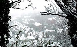 | | The Park, Nottingham, blanketed in snow (March 21st, 2001). Will we have snow this Christmas? |
| | We answer the big question of whether or not we will be having a 'White Christmas' in Nottinghamshire this year - with some odds!
Lukwesa Burak, BBC Radio Nottingham's forecaster, has the lowdown. |
| | | Predicting a white Christmas isn't easy because of how you define a "White Christmas".
What is a 'White Christmas'?
For many of us a White Christmas would be very similar to the scenes depicted on traditional Christmas cards or as described in Charles Dickens "A Christmas Carol". Ideally it would snow heavily, between midnight and midday on the 25th of December.
| 2002 betting odds | | We reckon the bookies would be offering 4/1 on a single snowflake falling in Nottingham if they were taking odds. |
But alas, with the all the placing and taking of bets, this definition has now become "for a single snow flake (falling as a wintry shower, hence a mixture of rain, sleet or snow) to be observed falling in the 24 hours of December 25th, and not necessarily snow lying on the ground".
Past Christmas Weather
The last truly white Christmas was in 1981 when snow lay on the ground for 21 days in December, and snow fell on 15 days.
| Statistical data: | A single snowflake falls on Christmas day 1 year in 5
We have a proper White Christmas (Dickens style)
1 year in 25 |
On the 28th December 1981, up to 28cm of snow was recorded through parts of the Midlands, and temperatures fell to - 11C/12F on the 13th.
The rest of the 80s were mostly very mild, with 1988 and 1989 having highs of 11C/52F - no chance of snow with temperatures like this.
 | | Lukwesa Burak |
The 90s were colder but mainly dry apart from just a few scattered wintry showers in 1992, 1993 and 1995. Daytime temperatures only recorded a degree above freezing.
Two years ago we had a few light snow flurries just after the 25th December and so was nearly classed as being a "White Christmas" for the betting fraternity!
Last year we drew a blank.
and finally this year
| Long term weather forecaster, Terry Scholey gives us his prediction | The chances of a true White Christmas on Christmas Day in Nottingham is small... but there is a chance of a wintery shower.
I think there'll be some sleet and a few flakes of snow before and after the 25th.
I don't expect anything big.
The best chance of snow this month is around the 11th/12th and 17/18th December and again on and around Boxing Day. |
William Hill are giving odds of 4/1 for a single snowflake landing in the cities of London, Cardiff, Aberdeen and Manchester. However, the MET office will only be monitoring for snow flakes over these four cities.
Therefore you might find it hard to put a bet on Nottinghamshire - might I suggest that this is a positive move.
The final word... " I'm dreaming of a white Christmas " ... really is just a dream in reality!
| The causes of a White Christmas | | Snowfall can occur in England any time from November to April, but it is impossible to predict at long range due to the unseasonable nature of our climate, it being dominated by a vast source of warm, moist air from the Atlantic, the spin of the Earth guaranteeing that in general winds are brought in from that direction. On occasion these winds weaken and that allows winds from a cold north through to southeasterly direction to affect us. | | The most common winter snow situation is the one following a cold, dry interlude with night frosts, where the ground and surface air is cold and winds may well have turned into the southeast. Then an approaching Atlantic frontal system, bearing warm air, rides over this cold surface air and ground and a period of snow ensues. Depending on the "push" of the warm air, this set-up can give several centimetres of snowfall, with typically eastern England most prone before it turns to rain and melts. On rare occasions such as Feb 1947 this process may be repeated several times with High pressure over the Continent reasserting the cold airstream. | | Another fairly common set-up is in a showery north-westerly, where Polar air has come south across the warm north Atlantic and this produces snow showers ( cold over warm - warm rises ). This is common in Scotland and many centimetres of drifting snowfall can occur over the Highlands in particular. | Fairly rare now too is when a Low get stuck in the North Sea and drags cold polar northerlies down eastern parts of Scotland and England, this can give several centimetres with drifting, due to frequent showers. Further inland to the west there is often just blue skies, unless, the winds veer to the northeast and the showers are brought further west before dying out. In January 1983 a particularly severe spell resulted in a great deal of snowfall produced by streaming showers over eastern and particularly SE England with parts of Kent being cut-off for several days. Overnight temperatures fell to minus 16C, and would have been much lower
if the wind had died. | | One last situation is where a cold air "block" of High pressure over the north and east of Britain is attacked by warm winds from the SW, and this too can give heavy drifting snow across southern parts of England. |
| | | |
|
|