RIVERSIDE HOUSING ESTATE, CASTLEDAWSON
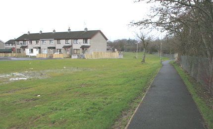
The site comprised of a choice of wet, grassy areas adjacent to the Riverside Housing Estate, straddling the bank of the River Moyola. The sites came about due to the demolition of disused houses as requested by the residents following anti social behaviour and dereliction.
The river itself supports many species including kingfishers, moorhens and even "problematic mink". The Moyola Angling Association, which has been going for 25 years, are very supportive of the planned initiative to enhance the area as they are actively encouraging salmon spawning on the 27 miles of river that they manage and they have a salmon and trout hatchery nearby. In fact, the Moyola River is the in top ten cleanest rivers to fish in in Europe.
Castledawson has its 300th anniversary in 2010 and the Community Development Association plan to incorporate the riverside area into a planned path to circle the whole town.
CASTLEDAWSON - PLANS AND PUBLIC PARTICIPATION
On Saturday 7th June the SWAT team swung into action. CVNI Project Manager Martin Lawson will led the project. Look at the full plan of the site.
With the help of Seamus Burns, the local biodiversity officer for Lough Neagh and Lower Bann Wetlands, the local council, the Housing Executive, the Fire Servcie and the robust community development association led by the Conservation Volunteers helpers were recruited.
The site was cleared, walkways introduced and planting interspersed between them to create a wildlife haven.
The transformation was cheered on by BBC Radio Ulster's Saturday Magazine between 10am and 11am.
Activities around the site were provided by the Ulster Wildlife Trust, CVNI, BBC NI, Moyola Anglers and many others.
MARTIN LAWSON TELLS US MORE ABOUT THE PROJECT
The basic concept is a winding path running through the grassed area linking with the existing paths and riverside walk. A circular seating area is surrounded with flower beds. A low bank between the existing path and the new one is planted up with shrubs. Standard trees are planted along the pathways. Approx. 200m of new paths.
The bank can be formed using material excavated for the paths, with topsoil over the top and bark mulch around any planting.
In the wet area, excavate a shallow scrape and line with plastic, cover with a layer of gravel, cobbles and large boulders forming a dry stream bed. Plant with wetland plants. This will form a series of puddles during the winter and dry out during the summer, eliminating the danger of a pond.
A mix of native trees and wildflowers, along with log piles and allowing the grass to grow forms a wildlife area where it is difficult to mow.
Fragrant and nectar rich plants can be planted around the seating area. A bog garden and block planting behind the houses can be left for a later phase. Standing stones, railway sleepers, posts, information signs etc can be scattered throughout to form focal points along the walkway as budget and time dictates.
Look at the full plan of the site.
USEFUL LINKS
Lough Neagh and Lower Bann Wetlands
Department of Culture Arts and Leisure
Antrim Borough Council
Lough Neagh Partnership
Moyola Angling Club
More about the
CVNI...»
More about

What's On in Northern Ireland...» |