Interview with Chloe Sarosh, Series Producer
Interview with Earth From Space's Series Producer Chloe Sarosh.
Published: 9 April 2019
In Madagascar there are so few trees to hold the islands red earth together that it’s leeching out into the rivers. From space it looks like the island is bleeding.
Can you tell us a bit more about what viewers can expect, and how this series is different to other natural history series on the BBC?
The BBC is famous for delivering stunning natural history series with cameras on the ground, in the sea and in the air. With access to cameras in space, this series tells the story of our planet and the natural world from a brand new perspective. Satellite imagery allows the audience to marvel in the sheer scale of the wonders on Earth, but to also explore some of its most remote landscapes and make startling discoveries.
The images from space alone are truly amazing, they’re works of art. But we were also able to use these satellite cameras to show the planet changing over time, to explore the planet’s most remote corners and to find and follow individual animals. It’s unlike anything we’ve seen on the BBC before. We think the audience will be amazed by what they see.
How did you go about taking a picture of an animal from space?
We weren’t entirely sure you could! Satellites take such detailed images that every pixel in the picture represents 30cm on the ground, so in theory you should be able to spot an animal. There was only one way to find out: we sent a team to Africa to attempt to capture an image of an elephant from space.
Firstly we needed to tell the satellite where to point, and so we worked with a charity which has GPS trackers fitted on several of the herds that ‘ping’ their location every hour. Using this information the camera team on the ground found the herd and set up their cameras, while the satellite took the image overhead. However, with the elephants constantly on the move and clouds to contend with, we were never sure that it would work. Watch this space!
How did you decide what stories to feature and what satellite images to use?
Some of the images taken from space are so startling, surprising and beautiful that we just had to explore the environment on the ground. For example, on the eastern edge of Brazil the green of forest gives way to a band of bright white. Zoom in and the most phenomenal landscape is revealed - such as white sand dunes covering thousands of kilometres. But if we look down at this landscape just months later, it is completely transformed - the rainy season fills the dunes, creating an endless sea of beautiful lagoons. From space we could time lapse images over weeks to show this transformation, while traditional filming allowed us to meet the animals that call this very special place home.
We also worked with scientists who are using satellites to explore Earth’s most remote corners. They are using the technology to make new discoveries but also to monitor the places on our planet that are under threat.
Was it challenging to combine satellite images with footage filmed on the ground and in the air to create seamless zooms down from space?
In some ways, no, because it’s such an exciting tool! The satellite cameras give us an opportunity to give an extra layer to the storytelling. It’s like having another cameraman, just one that’s 650km above the Earth’s surface! Some natural events are only visible when you step right back, for example the swirl of a gigantic phytoplankton bloom or the movement of Saharan sand across continents. However, working with satellites isn’t straightforward. They need to be in the right place at the right time and for the sky to be free of clouds. There were a lot of crossed fingers and held breaths as we waited for the images to come through, and a fair amount of disappointment!
The images taken by satellites are so huge and so detailed that you can quite literally zoom down through them. If you can fly a drone high enough in the same location and under the same conditions you can combine the two to create a seamless zoom.
The time lapses featured in the series are mesmerising as they capture a perspective that otherwise would be hard to appreciate. How did you put these images together?
Being able to take bespoke satellite images allowed us to take an image of the same location over days, weeks or months to show change over time. However organisations like NASA have been taking images of the planet for years, and by combining these we could reveal startling change, like the growth of cites or deforestation.
How do you think satellite images can help understanding our planet better?
It allows us to see the bigger picture, how interconnected the planet is. These images are a reminder of just how unique and beautiful our home is, but perhaps the most important and obvious revelation from this perspective is just how fast and dramatically the planet is changing. I hope that this series might go some way to inspire us to look after it.
What are the strangest discoveries that have been made by satellite?
Satellites are allowing scientists to explore the most remote landscapes without ever having to set foot on land. The world’s largest beaver dam, a lost world on top of an island of sheer cliffs and the biggest colony of Adelie penguins, have all been discovered from space. A corner of Western Australia is pocked with thousands of white spots which is evidence of an unlikely architect - wombats! And in Antarctica, previously unknown colonies of emperor penguins have been spotted by searching for their poo!
The most difficult place to get an image of?
The Oxbow lake in Brazil! It took us a year to successfully get an image of the lake as it was covered by cloud every day. It was a nightmare! Time after time we received completely white images as cloud covered the area, but we got it in the end.
The most surprisingly beautiful landscape and then the one that concerned you most?
Microscopic phytoplankton, some of the oceans tiniest organisms, bloom in their billions creating vast swirls of green and turquoise as they photosynthesize. I just love the fact that something so small can create these giant works of art.
The scale and speed of the loss of pristine forest habitat is truly shocking. In Madagascar there are so few trees to hold the islands red earth together that it’s leeching out into the rivers. From space it looks like the island is bleeding.
What moments are you most excited for people to see?
I cannot wait to share these images and this new perspective with the audience. It’s a visual feast! It will be like nothing they've seen before.
What is your most memorable moment whilst filming?
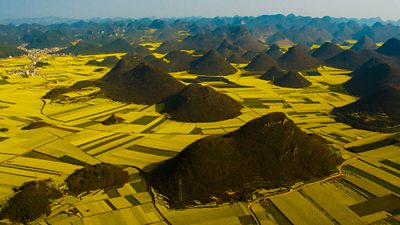
I was lucky enough to travel to China to film the rapeseed bloom. We are used to yellow fields in the UK but this was something else. We drove for a whole day and never left the yellow. It was incredible and the scale of the transformation from space as the flowers bloom is breathtaking.
Pictured: In China, the yellow of rapeseed flowers transform the landscape
"When I first started out on my journey with Earth From Space I travelled with Chloe Sarosh, Series Producer, and Barny Revill, Series Director, to a trade park outside Madrid. This is the headquarters of UrtheCast, the satellite imaging company who we were about to embark on a great adventure with.
Hanging on the wall were breathtaking images of the world from space. One of them was a design of perfect circles, a space-view of agricultural patterns in America created by circular irrigation arms. We were intrigued, delighted, amazed - and then our next thought was, what happens in the diamond shaped spaces between the circles?
When we looked into it we discovered they had been co-opted as conservation areas for breeding quails - tiny oasis of bio-diversity in what would otherwise be a mono-cultural bio-desert - and a great story for us!
This approach became part of our ethos in creating the series. Our mantra from the get-go was, what can satellite imaging add to the natural history genre that feels fresh, revelatory and from a new perspective?
What could you discover from space that you didn’t know before? How could these discoveries help scientists monitor the fragile health of our natural planet? How had animals helped make the extraordinary patterns that emerged only when seen from such a distance? And what were the strategies other species used to survive within these patterns? How have animals contributed to the rainbow hues that splash the world with vibrant colour?
We learnt so many things: that satellite cameras have revolutionised how scientists can monitor the natural world; how new populations of species such as penguins have been discovered; how we can follow migrating animals; how extraordinary lacy dune formations on the coast of Brazil become a filigree of pools where brightly coloured turtles hunt fresh water fish; how experts can monitor the health of coral reefs from the patterns of sand around them; how a wombat population is thriving from a landscape spattered with tiny marks that is their burrow.
In addition there is no doubt that images from space are simply awe-inspiring. Beautiful. Epic. Sometimes you gasp at seeing places you know from a different angle. Other times you simply can’t work out what on earth they could be.
One of our favourite games was playing guess the image. Turquoise swirls like abstract art turn out to be gigantic ocean blooms of microscopic phytoplankton that are the lungs of our planet. Black dots on a sandy background turn out to be rubbish dumps of old tyres in a desert, and what looks like an exotic coral fan turns out to be a beautiful delta in Guinea-Bissau.
And there is no doubt that the most sobering and extraordinary insight of all is being visually confronted with the incontrovertible truth of just how fast our planet is changing. Time-lapses over years show cities growing and swallowing up the countryside around them. Huge swathes of forests are decimated before your eyes or converted into regular agricultural patterns. Ice melts away from mountain tops and glaciers.
It is like having an exclusive ring-side view on how the planet works and the secrets hidden in its remote corners."
FS