24 September 2014 |

| |
BBC Homepage | |||
Contact Us | |||
History WalksYou are in: Derby > History > History Walks > The Matlock Trail 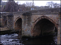 Matlock's 15th-century bridge The Matlock TrailUncover the history of this former spa town. This circular history walk has great views of some of the town's best-known landmarks. These include a castle that's not what it seems, a 15th-century bridge and a rare post box!
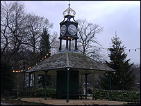 The former tram shelter The Matlock Level Trail starts and finishes at Matlock Bridge, with an optional half mile extension via Allen Hill. If you want, the Old Matlock Loop section can be done as a separate walk beginning and ending in Knowleston Place. The Matlock Level Trail starts on the downstream (south-eastern) side of Matlock Bridge. Look straight ahead towards the top of Riber Hill for an excellent view of Riber Castle. This well known local landmark is situated some 600 feet above the River Derwent. It's A 'pseudo castle', complete with four turreted corner towers and entrance block. It was built in 1863 as a private residence by the local textile entrepreneur, John Smedley (who also built Smedley's Hydro). 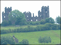 Riber Castle In 1892, the castle was bought for use as a school. During the Second World War, Riber became a food store and it then passed into the hands of Matlock Urban District Council. Over the years, the building deteriorated, but in 1963, the Hallam family established the Riber Wildlife Park there, which closed in 2000. Walk a few metres towards Crown Square. Stand in front of the entrance to Hall Leys Park, opposite the Tourist Information Centre. Look up the steep Bank Road, which rises from the roundabout in Crown Square. Towards the top of the hill (left), is a very large rectangular building with a central tower, complete with flag pole. This is now County Hall, originally Smedley's Hydro. This was founded by John Smedley, a local textile mill owner, in the early 1850s. Following its closure in 1955, the premises became the administrative centre for Derbyshire the following year, when Derbyshire County Council moved its headquarters from Derby to Matlock. Smedley's Hydro was initially so successful that lots of other buildings soon appeared on Matlock Bank. One of these was Rockside. You can see the distinctive turreted tower block behind Smedley's. Take a few steps to the junction with Park Head Road. Now look across the 'Square' towards the Tourist Information Centre, and turn slowly to the right through 135 degrees in order to view the buildings which face you in Crown Square. Crown Square (which is not really a square at all) developed in the 1880s and 1890s. The growth of hydropathic centres (hydros) on Matlock Bank created a demand for more shops and services. Nowadays, it is the accepted town centre of Matlock. The properties, mostly shops, arranged around the curve, link Matlock Bridge with Bakewell Road. They include the Jubilee Buildings the Archway, dated 1881 and the Princes Buildings (1894). Turn towards the Bakewell Road/Bank Road junction for a look at the former Crown Hotel. This was built in the 1880s but has been converted into retail premises. Further to the right, the Crown buildings, dated 1889, are located at the junction of Bank Road with Causeway Lane. The small tower at the top of the corner building appears to be a replica of the much larger tower which crowns County Hall at the top of Bank Road.  The former Crown Hotel A few yards along Bakewell Road is the 'new' Crown, a Pub occupying premises dating from 1899. Retracing your steps, walk 50 metres or so to the cenotaph, just inside Hall Leys Park, and face the shelter-cum-clock tower (a former 'tram' shelter), with Park Head Road on the left. The 'black mammoth' emblem, which may be seen at the back of the buildings at Park Head Road, was the trade mark of Burgon's, a former provisions company. 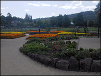 Hall Leys Park, Matlock The Tram Shelter, which used to be situated at the tram terminus in the centre of Crown Square, was given to the town in 1899 by Robert Wildgoose, a prominent member of the local community. The Matlock Cable Tramway operated between 1893 and 1927. It linked Matlock Bridge (Crown Square) with the hydropathic establishments which had been established on the hillside known as Matlock Bank. In 1889, the Council bought an area of land along the riverside, between Crown Square and Knowleston Place, from Henry Knowles. This was dedicated for use as 'a promenade and pleasure resort', ultimately becoming part of the Hall Leys Park when the council bought the remainder of the land. The park was enhanced when a group of shops between Matlock Bridge and Park Head was demolished in 1926. It underwent a major refurbishment in 2004/5. 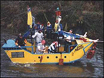 The annual Boxing Day boat race Walk about 25 metres to the Matlock Bridge viewing area. Dating from the 15th Century, Matlock Bridge was widened (on the upstream side) in 1904. Look at the underside of the arches to verify that this is a bridge of two halves. An annual Boxing Day charity raft race, with around 60 competing home-made rafts, has started from here since 1962. The viewing area was planned and built by members of Matlock Civic Association in 2005. Walk to the controlled crossing at Crown Square. Cross the road and walk back over the bridge (on the upstream side), turning right into the Station Approach. Continue towards Matlock Railway Station for a look at the former Station Master's house. 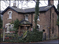 Station Master's house, Matlock This distinctive house, opposite the entrance to the railway station's former ticket office, was designed around 1850 by the architect Joseph Paxton. He was also the sixth Duke of Devonshire's head gardener at Chatsworth. Paxton's major projects included London's Crystal Palace and St Pancras Station, London. The Ambergate-Matlock-Rowsley section of railway line, which opened in 1849, connected Matlock Bridge (as it was then called) with Derby and the south. Whilst Matlock still retains this link, the extension to Manchester, completed in 1867, was a victim of the Beaching 'axe'. Around 1900, stone cutting was an important activity in the station yard area, reflecting the local importance of quarrying at that time. Return to the main road, keeping to the right, to the junction of the Station Approach with Dale Road/Snitterton Road. Take a look at the Bank here. Accessed through a distinctive Grecian-style portico, this early 19th-century building was at one time owned by the Nuttalls, a family of surveyors who produced plans and maps. In the 1860s, the property was used as a ladies' boarding school. Glance up Snitterton Road to the building which looks down towards the junction of Snitterton Road with Dale Road. This was used as a post office between 1811 and 1912. Before 1811, the nearest post office was in Matlock Bath. The road to the left of this is Holt Lane, which was the main route to Matlock Bridge from Matlock Bath before Dale Road (the current A6) was constructed. Take a look at the buildings at the properties at the far side of Snitterton Road. It's thought that a hostelry occupied this corner site, facing what is now Snitterton Road, as early as the seventeenth century. Apparently it was called Queen's Head since the 1780s. The present building, also formerly known as the Queen's Head, but now containing shops, dates from 1868. Cross Snitterton Road to the former Queen's Head, and proceed along the western side of Dale Road. Glance across to the eastern side of Dale Road for a look at the former Brown's Temperance Hotel. This building (now the offices of Potter, Brooke-Taylor and Wildgoose) was known as Brown's Temperance Hotel in 1878. By 1880, it had become a branch of the Derby and Derbyshire Banking Company (later, Parr's Bank). It was purchased by Mr James Potter, a solicitor, following the bank's move to the brick-built property next door in 1902. Continue to the pedestrian crossing. Cross to the eastern side of the road and stand outside the former Brown's Temperance Hotel. Look back across the road to have a look at the old Market Hall. Dating from 1867, this was designed by W Hall of Northampton, and housed shops and market stalls on the ground floor, with an assembly room for 500, seated, above. Council business was also conducted from here. Continue along Dale Road (towards Matlock Bath) as far as the junction of Dale Road with Olde Englishe Road. Here you'll see The Old Englishe Hotel. This Victorian Gothic building replaced an earlier hotel, which was destroyed in a fire. Cross Olde Englishe Road and continue along Dale Road towards Matlock Bath. Look up, straight ahead for a view of the War Memorial on Pic Tor. On your left you'll pass W Evans & Son (Jewellers) Ltd. William Evans founded his jewellery business in Wirksworth in 1850. His son, Walter, brought the company into these newly built premises in 1894. The Former Picture Palace, now home to a firm of auctioneers dates from 1913. Continue along Dale Road (A6 towards Matlock Bath) as far as the railway bridge. Immediately before this bridge is a small garden, located between the A6 and the river. The garden was created on this site by Matlock Civic Association in 1983 - look out for the plaque. In 1848, the Great, Little and Upper Ship Loads were the names of three fields between the river and Holt Lane (opposite). In 1767 a 'Shiploades' Mine existed. 'Le Shiploade' is recorded in 1417. It means 'a river crossing for sheep'. Retrace your steps as far as Olde Englishe Road. Bear right and walk for a short distance along this road as far as the right-hand bend. Continue straight on, through the sensory garden. Originally dedicated to blind people, the garden between Olde Englishe Road and the footbridge (into the Hall Leys) was sponsored by the Rotary Club of Matlock, in conjunction with Matlock Urban District Council in 1954. Following refurbishment in 2003, it was re-dedicated as a sensory garden to celebrate the 75th anniversary of Matlock Rotary Club. Leave the garden via the footbridge over the Derwent. A wrought iron lattice bridge with timber planking, has linked Olde Englishe Road with the Hall Leys since the 1920s. The River Derwent at Matlock has been prone to flooding in the past and marker boards, at the Hall Leys end of the bridge, indicate the height of the river in 1960 and 1965, when the last major floods occurred. Having crossed the bridge, turn sharp right on to the Broad Walk, which runs parallel to the river through the Hall Leys. Immediately before the exit ramp at the end of Broad Walk, with the children's playground on the left, look right towards the river. At the top of the river bank, notice the the memorial stone to P.C.Wright. He lost his life in 1911 trying to save someone from drowning. Proceed into Knowleston Place via the humped ramp. In 1983/4, Severn-Trent Water carried out major works in an effort to prevent future flooding. These works included the installation of three access ramps into the Hall Leys Park, one of which is here, where Broad Walk joins Knowleston Place. Other ramps were located at the junction of Knowleston Place with Causeway Lane and along Causeway Lane, opposite the end of Firs Parade. These ramps, together with a pair of retractable flood gates (midway between the access ramps from Causeway Lane) enable the park to be used as an emergency 'containing reservoir'. Continuing straight ahead, notice the properties on the left. A cottage (number 3, dated 1621), followed by a bay to Derwent House (dated 1772) and Derwent House itself (number 5, 1753), show that this part of Matlock was settled relatively early. During the 17th and early 18th Centuries, various industrial processes, including lead washing, tanning and flax dressing were carried out along this final stretch of the Bentley Brook (before its confluence with the Derwent). Beyond Derwent House is a fine terrace (numbers 7-13) built by John Knowles in 1857 (Hence Knowleston Place). Notice Knowles's decorated stone obelisk, which stands in the garden of number 9. Cross over Bentley Brook via the small footbridge opposite the obelisk, waymarked as the Derwent Valley Heritage Way. Wheel chair users may avoid the steps by proceeding along Knowleston Place for few metres, turning right into Stoney Way and immediately right again, through a narrow gateway at the far side of the brook. This path joins the waymarked 'short cut' from the obelisk. On the right (as approached from the small footbridge), in a secluded grassy area, is an old stone base for a gas light. The inscription on the stone reads "A GIFT TO HIS NATIVE PARISH BY JOHN KNOWLES ESQ 1867." It appears that this was actually the base for a gas light, which used to be located at the centre of Matlock Green. The gift referred to may have been the gas light, complete with stone base. The Old Matlock Loop may be included here. The Loop, which is not suitable for wheel chairs, adds approximately one mile and an hour to the overall time. For a route description of the Loop, please see the section called 'Old Matlock Loop' at the end. If you're not taking the Old Matlock Loop, bear left at the footpath T-junction immediately beyond the gas light, go through a gateway and turn left into Stoney Way. Facing you is Brook House which has a 19th-century portico. Turn right in front of Brook House to rejoin Knowleston Place. Pass along the front of a block of terraced houses, and then between a couple of posts into an alley, where there is a good view of Riber Castle. The alley leads into Matlock Green. On the right is Tawney House, formerly the Parochial Hall. Funded by a Mr Bailey, the Parochial Hall, complete with gymnasium and reading room, opened in 1897. In 1962, the Workers’ Educational Association took over the establishment (which later included the adjoining house) to use as an adult education centre. They renamed it Tawney House in recognition of Professor R.H.Tawney's pioneering work for the Association. The adult education centre closed in 2004. Using the pedestrian crossing, cross the road to The Red Lion. There has been a public house on or near this site since the 17th Century and the name dates back to at least 1780. Turn right and walk to the junction with Lime Tree Road, passing in front of Matlock Green Shops. The shops between the Red Lion and the junction with Lime Tree Road date from the late 18th and early 19th Centuries. The former post office, with its rare VR Post Box and Victorian front, stands on the corner of Matlock Green with Lime Tree Road. Pause at the junction, opposite the Horseshoe. Look up Lime Tree Road. Immediately behind the Hoeseshoe is The Blacksmith's Shop. John Froggatt, a landlord of the Horseshoe, ran a wheelwright’s business from here. Continue to a point opposite and just beyond the filling station. Glance across the road for a look at a couple of contrasting properties. These are The Swiss Cottages, The old water-powered corn mill, just beyond the Swiss Cottages was converted into luxury apartments in 2005/6. 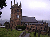 St. Giles's Church Retrace your steps to Tawney House via the pedestrian crossing. Pause at the end of the alley which leads into Knowleston Place, and look slightly upwards (in the direction of the alley) for a good view of St Gile's Church. Brief details about the church are included in the Old Matlock Loop route below. Staying on the Tawney House side of the road, walk up the rise towards Matlock town centre (using the rather narrow footpath on the left hand side of the road). Beyond the top of the rise, across the road (Matlock Green), on the right, are The Harrison Alms Houses. The block of six units was built to 'provide rest for the aged poor'. The foundation stone was laid on 22nd June, 1897, the day of Queen Victoria's Diamond Jubilee. last updated: 06/04/2008 at 18:28 SEE ALSOYou are in: Derby > History > History Walks > The Matlock Trail |
About the BBC | Help | Terms of Use | Privacy & Cookies Policy |