ROUND 3: MALAYSIAN GP, Sepang, 2-4 April 2010
(This forecast will be regularly updated. This entry: Sun. 4 April, 07:15hrs BST)
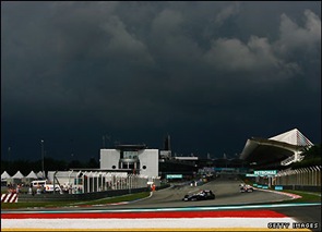
NOWCAST UPDATE, Sunday 09:40hrs: No immediate threat of showers - doubtless a relief for certain teams!
NOWCAST UPDATE, Sunday 08:45hrs: As noted below, the distinctly capped look to the clouds was very evident as a backdrop to Martin's gridwalk a moment ago. Bernie Ecclestone suggests rain at 4.15pm but the clouds say otherwise! Dry running for the start; probably the 30mins thereafter and we'll then see how the shower threat increases as the race is underway. It could all change very quickly indeed.
NOWCAST UPDATE, Sunday 08:15hrs: Crucially, there's less potent convection around compared to the same time yesterday; the growth of the cumulus clouds is presently capped aloft, preventing widespread showers for now. However, if this capping breaks-down later (and it probably will), we will see the shower cells tower up very quickly and energetically. But where, exactly? And when? Later in the race looks at risk. It's going to be another situation where watching radar alone is not sufficient insurance against red faces on the pitlane: cloud watching will be equally important.
NOWCAST UPDATE, Sunday 07:15hrs: Well, the day has followed a familiar pattern thus-far: a very hot, sultry, dry morning in Sepang. Latest forecast expecations continue much as previously advertised, with showers expected to tower-up through the late afternoon before turning thundery in places and organising into bands parallel to the west coast. The influences of topography and low-level convergence will again tend to preferentially form shower cells east of the circuit, before these move west in the prevailing light winds. Risk of wet weather at some stage of the race is around 70%. As we saw yesterday, this could be realised even before the lights go out at 4pm local time...
------------------------------------------------------------
NOWCAST UPDATE, Saturday 09:55hrs: These conditions are exactly as I expect by this time tomorrow, too. No real surprises. I'm amazed that some teams followed the radar so slavishly as to assume a dry window earlier in Q1. In these developmental situations, it was always very likely that the cells would rapidly evolve into thunderstorms. As any storm chaser will attest, a clear slot evident on the radar in this type of set-up doesn't equate to a guarantee of dry weather... far more cloud-watching is required, me thinks, rather than myopically watching the radar feed!
NOWCAST UPDATE, Saturday 09:28hrs: Further heavy showers imminent.
NOWCAST UPDATE, Saturday 08:50hrs: And as expected... the first sign of showers duly arrives over the pitlane.
NOWCAST UPDATE, Saturday 08:45hrs: Towering cumulus around the circuit now; showers look imminent and it's all about exactly where they start to deliver rain. In this rapidly-developing situation, a few hundred metres makes the difference between a wash-out or staying dry!
NOWCAST UPDATE, Saturday 08:10hrs: No significant change to the original forecast - showers expected to edge ever closer towards the qualifying hour and so it'll prove a nail-biter for the teams (and us!). Worth adding a clarification from my colleague Sarah Holt, in Sepang: "We understand the rules of rain to be as follows. If it comes down at 1600 local time (0800 BST) to delay qualifying, then there is a three-hour window to get the job done. If it's not safe to get out on track in that time then qualifying will be held on Sunday morning. If the first qualifying session opens but no times are set then the teams will also come back on Sunday. If times are set from Q1 onwards, but the weather prevents the third session taking place, then those times will dictate how the grid will be formed for the race."
NOWCAST UPDATE, Saturday 07:00hrs: So, some close calls as showers passed by the circuit during P3 but will Sepang evade them in qualifying?
NOWCAST UPDATE, Saturday 06:30hrs: McLaren suggesting showers imminent. A tricky aspect for all the teams at this stage of the afternoon is how rainfall radar can be misinterpreted. The growing convective cells can often seem suggestive of rain on the radar, whereas in reality no precipitation is actually reaching the ground...yet. But we're now at a tipping point, weatherwise, where the showers will increasingly become a reality.
NOWCAST UPDATE, Saturday 06:10hrs: The first showers are starting to appear on rainfall radar near the circuit. A growing prospect now of some interruption from wet weather... depending on the precise trajectory of the slow-moving shower cells.
NOWCAST UPDATE, Saturday 05:55hrs: A very hot day has been developing at Sepang and we've got the risk of heavy showers developing through the afternoon now. The Cumulus clouds are already starting to readily tower-up near the circuit but for now it's dry and should stay that way for at least part (if not all) of P3. Air temp. 31C; track temp. 46C.
------------------------------------------------------------
NOWCAST UPDATE, Friday 09:30hrs: P2 escaped the showers, but they were visibly building east of the circuit by the end of the session as the outflow winds from these cells began blowing the palm fronds about. Rain has duly arrived across Sepang just after 4pm local time... and clearly, a repeat performance of this during tomorrow's qualifying could really throw a major variable into the eventual pecking order. We shall see!
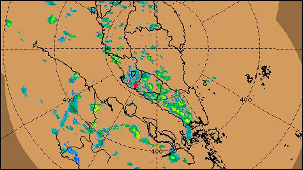
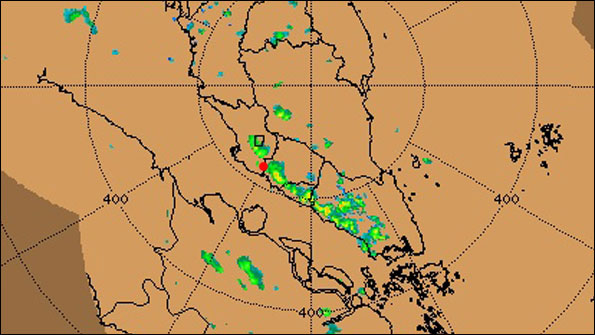 Rainfall radar at 3.40pm local time on Friday (TOP) shows heavy showers starting to form just east of Sepang Circuit (red dot) and moving west. Just after 4pm, rain started falling across the track. By 4.40pm (BOTTOM), the shower and thunderstorm cells were become organised as a line, orientated and forced by sea breeze low-level convergence and threatening further torrential downpours into Sepang. Could Saturday see a repeat as qualifying gets underway? (Image: Courtesy Malaysian Meteorological Department)
NOWCAST UPDATE, Friday 06:35hrs: Showers are forming east of the circuit inland, some looking quite lively on rainfall radar. Sepang at risk of some into P2; they've already seen one over the circuit as my colleague Sarah Holt can attest! Track temperature has reached over 50C... tyre degradation could prove very interesting to monitor.
-------------------------------------------------------
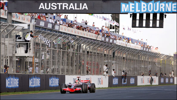
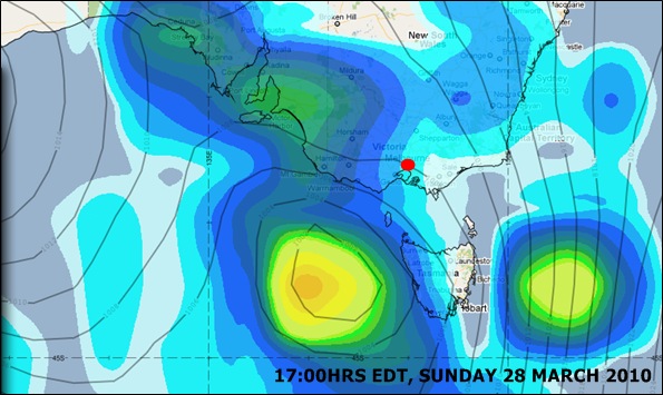
So, what a difference a bit of rain makes.
As Andrew Benson blogs here, the Australian Grand Prix served as a timely reminder that Formula One can still deliver a highly entertaining and unpredictable spectacle, not least after the processional race witnessed in Bahrain.
Throw a sprinkling of wet weather into the mix and anything can happen in Formula One, "...and usually does," as Murray Walker would say.
Off next to steamy Malaysia, where the risk of further spells of wet weather, this time in the shape of heavy showers and thunderstorms, is almost omnipresent.
Climate & Local Weather
And guess what? April is the wettest month of the year... albeit not at Sepang itself!
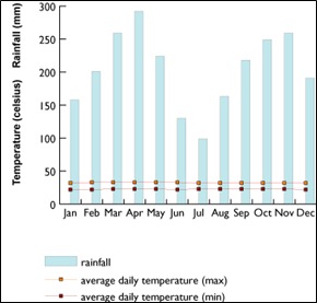 On average, the capital Kuala Lumpur - just north of Sepang - sees 279mm (11 inches) of rain falling during April, with temperatures typically close to 30C and humidity usually around 70-80%. The regional rainfall pattern throughout the year in this equatorial climate is very variable across Malaysia, with distinct drier (inter-monsoon) periods coupled to much wetter months. In the southwestern coastal districts of Peninsular Malaysia - including Sepang - the daily weather at this time of the year tends to follow a broadly similar pattern, but local affects of topography, prevailing sea breezes, urban 'heat islands' and other factors can greatly influence rainfall distribution.
At the Sepang Circuit, March typically yields 154mm of rain, but April only 98mm. Both months see an average of 15-16 rainy days (data supplied by Malaysian Meteorological Department). The wettest months there are typically October, November and December.
Mornings at this time of year are typically dry, partly sunny affairs. The temperature - which remains noticeably high and oppressive even overnight - then peaks into the mid to late afternoon, aided in part by insolation. This thermodynamic forcing, combined with generally light winds and a sea breeze convergence zone offering additional lifting mechanism; high humidity and deep instability aloft in the atmosphere, is a recipe for rapid thunderstorm development and these can prove slow-moving once formed.
Typically, the storm cells initially form into the late afternoon and evening - east of the circuit, in the convergence zone - and then migrate westwards, steered by the prevailing gradient winds aloft. A variation of this, where an organised, vigorous line of storms develops through convergence over the Straits of Malacca and then moves east to affect southern Peninsular Malaysia, is known locally as a Sumatra Squall.
We saw the dramatic results of diurnal / sea breeze convergence thunderstorms during the 2009 race, which was ultimately red-flagged as lightning struck repeatedly around the circuit and a downpour of biblical proportions started drenching the track and pitlane by lap 31.
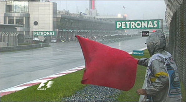
Red flags bring the drenched Malaysian Grand Prix to a premature finish in April 2009. Organisers will hope that with a 4pm local start (9am BST) this year, thunderstorms remain at bay for a while longer...
Weather at previous races
The history of this event is, for the most part, actually one of dry races - despite running in three different months.
The inaugural F1 race at Sepang was in October 1999. It was dry. Ditto 2000. In 2001, it was moved forward to March - with a heavy shower affecting the race - and it remained a March event through to 2006, with dry running largely prevailing during this time (2004 was an exception, in part).
In the 2007 calendar, the Malaysian GP shifted to April, with showers a constant looming threat during practice and qualifying sessions, albeit they didn't materialise during the race. The following year - with the race moved back into March - it remained dry.
The return to April in the 2009 season brought the torrential rain and utter chaos noted earlier. At the time, with the race finishing so prematurely on lap 33, there was considerable criticism of the 5pm local start time (to suit European TV audiences) when storms were likely to be very prevalent. But Bernie Ecclestone's response was typically bullish:
"No, I just have regrets about the rain," he said. "I don't see anything wrong with the start time, we just didn't know about the rain."
Well, forewarned is forearmed. And this time, the race starts an hour earlier - but will that prevent the risk of a repeat performance? Don't count on it...
Sepang weather prospects for 2010...
 The precise forecast detail for each period of track action in Sepang will prove impossible to pinpoint until very near to the time, because of the localised nature of shower and thunderstorm development. For that very reason, it would be a forecasting folly to even attempt this a few days ahead - and I won't try to! The rapid storm development means teams need to be sky-watching and ready to change strategy extremely quickly - as Steve Nielsen, Renault's sporting director, stresses:
"There's a good chance of heavy rain showers, which may only last for a few seconds, but completely soak the circuit."
Indeed so. However, by definition, there's a higher statistical chance of dry running during any one session rather than wet, so in the comments below I've emphasised the broad % risk of showers.
I do stress it'll be very much a nowcasting situation - something the teams will be very acutely aware of in their preparations and assimilation of weather predictions. Vice-President of Mercedes-Benz Motorsport, Norbert Haug, sums up the Sepang scenario thus:
"As usual for this race, we have to expect extremely hot and humid conditions, usually accompanied by torrential rain showers every now and then - a race in sauna conditions, virtually. This climate is the greatest challenge for the teams, cars and drivers."
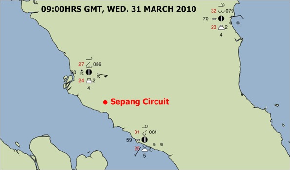
Surface observations around Sepang reported at 0900hrs GMT (5pm local) on Wed. 31 March illustrate the weather lottery posed for qualifying and the race. Had this been Sunday, the race would have been running an hour by this stage. Moderately heavy thunderstorms and 27C are being reported at nearby Kuala Lumpur, whilst it remains dry and hazy further south in Malacca. An hour earlier, showers were already falling around Kuala Lumpur, which had reached a sizzling 33C.
Note that the Lifted Index values (combined with CAPE) from coarser-scale forecast modelling across Peninsular Malaysia offer a latent risk of thunderstorms across almost every session but as you'd expect, this is most pronounced into the late afternoon when some storms could turn very lively indeed. Radars at the ready, then...
Here's the early forecast essentials:
FRIDAY:Should be effectively dry running.
Practice 1 gets underway at 10am local time. Hot & sultry, as temperatures reach 30C with light winds, predominantly easterly. Latest modelling suggests dry, partly sunny weather should prevail, with a low chance of scattered showers even at this stage (20%). By Practice 2 (2pm local time), there's again a good chance of dry running for the teams, but a somewhat higher prospect of showers or thunderstorms looming (40%) as temperatures peak around 33C. Winds remain light. Latest meteograms for nearby Kuala Lumpur continue to suggest Friday could ultimately prove the wettest 24-hr period of the weekend, but it's very likely the heaviest downpours will gather only after the track action finishes and then develop into the evening.
SATURDAY:A growing risk of thundery downpours developing by and during qualifying.
Overnight spells of heavy rain from thunderstorms are likely, leaving the circuit 'green' once again. By the time of Practice 3 (1pm local time), largely cloudy weather will prevail with a 50% chance of showers; surface pressure about 1010mB and temperatures around 32C. By Qualifying (4pm local time), the risk of local showers is rising (and has been enhanced in latest modelling) to around 60% and effectively increases throughout the hour (something the teams will be monitoring closely towards Q3!); winds remain light easterly and typically <5kts (unless actually in the vicinity of any storm cells, where they'll be noticeably gusty and variable) and humidity up above 90%. Very uncomfortable sitting snugly in a cockpit wearing racing overalls, for sure. The modelled rainfall accumulation signal for Saturday is 'noisy' - as expected for this location - but somewhat less enhanced, compared to Friday.
SUNDAY: Risk of thundery downpours during the race, most especially after mid-distance.
The previous evening's showers have likely 'washed' the circuit once again. A minority of models keep any (decaying) nocturnal shower activity alive cross coastal parts of western Peninsular Malaysia even until about 0800hrs local time. The morning then looks dry, continuing in similar fashion into the early to mid afternoon. The race gets underway at 4pm local time and critically, some models (plus recent persistence forecasting) offer a risk of isolated downpours even by the start. Thereafter, the risk of shower or thunderstorm development continues to gather pace over the next 2 hours and as on each day of this event, the 'devil will be in the local detail'. Again, the broader cumulative rainfall signal is less pronounced than Friday but similar to Saturday. The risk of wet weather is around 45% at the start of the race, rising to 65% by the end; winds remain light east to east-southeasterly; humidity about 90% and temperatures around 30C.
Note: Due to ongoing upgrade work with national rainfall radar network (also in Singapore), updates to the Malaysian Meteorological Department's real-time radar feed on their website are currently intermittent. They tell me efforts are ongoing to resolve any disruption to this service.

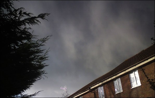

 My cats certainly agree... they're currently sprawled over parts of the back garden, basking like a pride of lions (the youngest is shown, right - it's her first-ever spring).
 I'm Ian Fergusson, a BBC Weather Presenter based in the West Country. From benign anticyclones to raging supercell storms, my blog discusses all manner of weather-related issues. I also provide updated race weekend forecasts tied to our BBC coverage of Formula One. You can follow me on