
We'll get a taste of summer over the next few days. It'll be a fine and dry start to the week with sunny spells and it will feel warmer.
Monday afternoon will see plenty of sunshine - just a little hazy at times with some patchy cloud around, but turning warmer for most of Wales with highs of 13-17°C.
High pressure on Monday evening will keep things fine and dry. Under the clearer skies overnight temperatures will drop away again - 2-8°C in towns and cities, but colder than that in the countryside.

Gwbert sunset by Dannie Evans
Tuesday morning will have some early mist - possibly even a few frost patches - but not for long. It will soon warm up again in the strong spring sunshine - remaining dry with just some fair-weather cloud around and very light easterly winds. Temperatures will climb into the mid-to-high teens, possibly even low 20s. The average daytime temperature for Wales in mid-April is 12°C.
High pressure brings more settled weather on Wednesday. There'll be more sunny spells and warmer than average temperatures but maybe a bit more cloud for border counties.
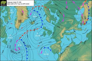
Weather map 21 April 2015
But then we'll start to see some changes later in the week. High pressure will slip away northeastwards, allowing fronts to push in from the Atlantic.
Thursday might start fine and bright but it'll turn increasing cloudy with rain arriving from the south-west late on Thursday night and into Friday.
So, after a few settled days there's a more changeable end to the week with some rain by Friday. It will be a bit windier too, but it will still feel relatively warm because of the south-westerly winds. It looks like it could be a bit cooler and more unsettled next weekend.
Next week it looks like we'll be returning to a more typical 'sunshine and April showers' scenario.
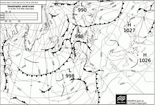
Weather map 24 April 2015
