
December has been a wet and very mild month so far. We haven’t broken any records in Wales yet but it has been unusually mild.
Last Saturday temperatures reached a spring-like 13-16°C, well above the average which is nearer 8°C, so it’s no wonder some plants, flowers and wildlife are confused at the moment with daffodils already blooming in some parts of the country.

Daffodils by Paul Simon from Connah's Quay
The reason for the warm weather is the wind direction with south-westerly winds bringing moist air to us from the Azores. A strong El Niño over the tropical Pacific may also be affecting our weather.
Over the next few days the weather is going to be very up and down. There's more rain and strong winds on the way on Tuesday with a yellow warning of heavy rain in force for parts of mid, north and west Wales.
The rain will be heaviest on the hills and mountains with a risk of further flooding in places.
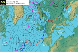
Met Office weather chart up to Christmas Eve
The rain will clear to heavy showers on Tuesday night and it will turn a little colder. Wednesday should be a better day: drier and brighter with some sunshine and only a few scattered showers.
Overnight into Christmas Eve, low pressure will bring more rain, with some heavy rain clearing to showers in the afternoon. These will turn wintry on high ground in the north with a little snow on Snowdon.

Snowdon by Kris Williams
Christmas Day looks set to be a little chillier and more seasonal. Probably dry and bright for a while with just the odd shower but more wind and rain will spread from the south-west later in the day. It looks like it will be turning mild again as we head into Boxing Day.
So I can't promise a white Christmas in Wales this year but from everyone on the weather team, we wish you a very happy Christmas. Nadolig Llawen!
