
It's been a wet few days in mid and north Wales with some flooding. At Lake Vyrnwy in Powys, 189.4mm of rain has fallen since the beginning of the month, more than than the February average which is 138.7mm.
Some rivers are swollen and at the time of writing there are three flood warnings in the lower and upper Dee Valley and at Bangor on Dee. We've had some amazing photos sent in too, with the River Dee resembling a raging torrent.

A local fireman saving a sheep in the flood at Bangor-on-Dee this morning. Image by Joe Hughes.
The wind has also been a big feature recently with strong to severe gale force again today with gusts between 50 and 70mph and 84 mph at Aberdaron on the Lleyn Peninsula.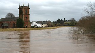
Flooding in Bangor on Dee today. Image by Ian Humphreys.
The strong winds will gradually ease during the rest of today and tonight will become dry with light winds but colder than recently with a slight frost.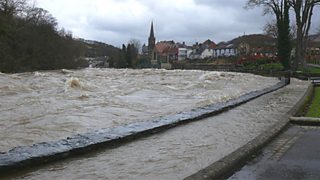
The River Dee on Sunday, 6 February 2011 showing the highest recorded water level since 1964. Image by Colin Roberts.
Tomorrow most of the day will be dry and bright with some sunshine thanks to a ridge of high pressure but make the most of it, because the day will end damp and breezy with a warm front bringing more cloud and rain in from the Atlantic.
The rest of the week will be very changeable with rain at times. However, it should dry and brighten-up on Thursday before the next batch of rain arrives!
There is a hint that a large blocking anticyclone will build over Scandinavia from 11 February onwards so it could turn much colder later in the month with easterly winds.
Remember the 2009 November floods? See the pictures.
Derek
