
We've enjoyed plenty of sunshine recently but the sky hasn't been totally clear everywhere today. Cumulus clouds brewed-up inland in Pembrokeshire, Ceredigion, Carmarthenshire and Gwynedd.
These clouds are caused by what is known in meteorology as convergence. This is where two winds from different directions meet or converge e.g. a sea breeze and land breeze.
Convergence causes the air to rise and cool and form clouds. If conditions are right, then these clouds can grow big enough to produce heavy showers and thunderstorms.
The satellite picture for 14:00 UTC (3pm) this afternoon also shows a bank of cloud over England, this is a weak cold front. It's moving south-west bringing slightly cooler and fresher air. So tomorrow will be dry and sunny but it will feel fresher than today with lower humidity.
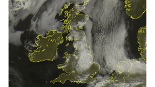
Satellite chart for Wednesday 10 July. Image © Sat24.com/Eumetsat/Met Office
South Wales has been one of the warmest parts of the UK on recent nights this week. Tomorrow night will be a more comfortable night for sleeping but temperatures and humidity levels look set to rise again on Friday and Saturday before turning fresher once more on Sunday.
