
This is my last day at the Eisteddfod in Llanelli and we've been lucky with the weather.
There was a heavy downpour on Tuesday evening, which left behind a few puddles on the Maes field, but apart from a few showers we've enjoyed plenty of dry weather and sunshine, and it hasn't been too hot with refreshing sea breezes.
There's more fine weather to come today and tomorrow with just a few scattered showers and sunny spells but it's a different story for Sunday.
The remnants of ex-hurricane Bertha, currently over the Atlantic, are still heading towards the UK.
This may bring a spell of unseasonable weather, with a risk of heavy rain and potentially strong to gale force winds.
There is also a risk of coastal flooding on the Bristol Channel coast due to the combination of high spring tides and strong onshore winds.
However, Sunday's forecast is very tricky and subject to change.
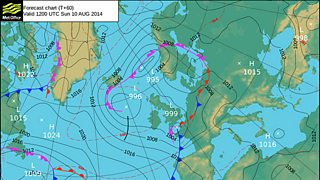
Forecast chart Friday 8 August 2014
The chart for Sunday from the Met Office shows low pressure over the English Channel.
It doesn't look too threatening but other computer models that we use to help predict the weather have the low in a different position and deeper; it could go further north across the UK or even further south into northern France as a weaker system.
Deciding the exact path the storm will take is proving difficult, even at this stage, and a real headache for forecasters.
The jury is still out, so the advice is to keep a close eye on the forecast over the next couple of days.
