The heatwave has well and truly arrived! Yesterday was the hottest day of the year for most of Wales, with Cardiff the hottest place with a high of 28.3°C.
But it wasn't hot everywhere. Aberporth on the Ceredigion coast only reached 18.7°C with a breeze off the sea. There was even the odd patch of sea fog, for example in Fishguard.
South Wales was also the warmest part of the UK last night - in Cardiff and Swansea the temperature didn't drop below 18°C making it uncomfortable for sleeping.

Brecon Canal - photo by Clive Rees of Merthyr Tydfil
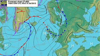
The high pressure responsible for the summery weather is going to stay in charge of our weather for the rest of this week so the emphasis is on plenty more fine, very warm weather and sunshine but there will be subtle differences from day to day.
On Wednesday afternoon and evening, there is a small chance of a shower breaking out on the high ground in Wales. A weak cold front will bring some cloud later on Wednesday, overnight into early Thursday but this will only introduce slightly cooler, fresher air.

Met Office forecast chart
At the moment, it looks like south east Wales will be hottest next Saturday and here there is a risk of a heavy shower or thunderstorm otherwise most places dry. Sunday may turn cooler and fresher everywhere.
Next week the charts suggest plenty more dry weather. Not as hot as now but still on the warm side, especially in the south and east.
