
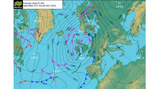
The weather is unstable at the moment with low pressure over Ireland. The low is going to tighten its grip in the next 12 hours bringing more heavy showers, thunder, rough seas and stronger winds too.
There is a Met Office warning in force for southern counties from Pembrokeshire across to Cardiff until 9am tomorrow. Gusts of 50mph are likely and 60mph is possible on exposed coasts and headlands such as Mumbles Head in Swansea.
There's also a risk of flooding on parts of the south and west coast with a full moon and high tides combining with strong onshore winds. This will create a small surge along the Bristol Channel coast.
Derek Brockway weather forecast valid until 9 October 2014
There are currently several flood alerts in force.
Here are the tide times.
The north coast will escape a surge because the wind is south-westerly and offshore.
Further occasional showers are likely tonight and tomorrow. Some of them heavy and squally with a risk of hail and thunder in places but with some drier spells and sunshine as well, especially later in the afternoon. Top temperatures tomorrow 12 to 16 Celsius and the strong wind in the south will ease.
