
Several centimetres of snow fell in places last night giving us icy roads and pavements this morning and temperatures in Libanus near Brecon dropped to -4 Celsius.
Today there is a line of showers over the Irish Sea and south west Wales today known as the Pembrokeshire Dangler!
If the air is cold enough the Dangler can bring heavy snow to Pembrokeshire, Cornwall and west Devon as well as hail and thunder.
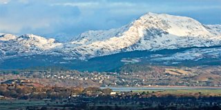
The view from Harlech Castle of newly fallen snow on the Snowdonia mountains - Eddie Evans
Tonight will be dry with a widespread frost and a few freezing fog patches.
Temperatures in Powys and the Marches with fall as low as -6 or -7 Celsius with icy patches.
Wednesday will be largely dry with low cloud and fog lifting with some sunshine for most of the country.
Parts of the east may stay grey though into the afternoon and feel cold with highs between 0 and 3 Celsius.
On Thursday, most of Wales should be dry but I wouldn't rule out a little rain or snow in parts of the north and west coast.
Friday will be very cold and windy and there is a risk of more widespread snow as fronts try to move in from the Atlantic.
Some significant falls of snow are possible with blizzards and the Met Office has issued a yellow alert.
There is some uncertainty in the forecast for later this week so stay tuned for updates over the next few days on BBC Wales Today and BBC Radio Wales.
You can also follow me on Twitter @derektheweather
