
It feels quite muggy at the moment with southerly winds bringing warm and humid air up from Spain and the Bay of Biscay.
RAF Valley on Anglesey was the warmest place in Wales yesterday with a top temperature of 19.7 Celsius.
The average maximum for October for this location is nearer 14 Celsius http://www.metoffice.gov.uk/climate/uk/averages/19812010/sites/valley.html
Over the next couple of days, it's going to stay very mild but wet and breezy at times with showers or longer spells of rain.
Some of the rain will be heavy and thundery and the Met Office has issued a yellow warning (be aware) valid from 6pm today until the end of Thursday.
Some torrential downpours of rain are expected in places: 20 to 25mm in an hour and 40mm in 3 hours with a risk of localised flooding although some places, especially in the north, will receive less than this.
On Thursday night the worst of the heavy rain will clear away and Friday will be a better day; breezy with a few showers but on the whole drier and clearer with a moderate south-westerly breeze.
Over the weekend, high pressure will move up from the southwest across southern Britain.
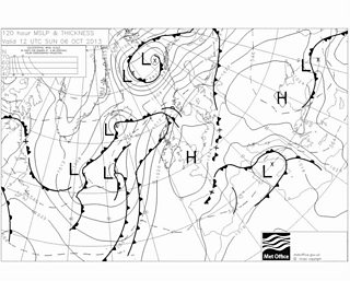
weather chart for Sunday
This will bring much more settled conditions. Some sunshine is likely and the nights will be cooler with mist and fog patches forming which may be slow to clear given the wind will be light, and may linger all morning in a few places.
However, in the sunshine it will feel quite pleasant with temperatures in the afternoon reaching 15 to 18 Celsius.
