
The clocks go forward this weekend marking the start of British Summer Time but unfortunately the weather is about to take a turn for the worse! A strong jet stream over the Atlantic and low pressure will bring spells of heavy rain with strong to gale force winds.

Incoming rain at Church Stoke at sunset by Ros Baylis from the BBC Wales Flickr group
Friday evening will start dry but overnight a warm front will bring a little rain and drizzle. The cloud will lower with mist and fog patches. The wind will pick up after midnight and it will turn milder. Temperatures will reach 8-10°C by the end of the night with a south-westerly breeze.
Saturday may start dry apart from a little drizzle but a cold front will move south-east during the morning bringing a short spell of heavy rain with strong and gusty winds. The rain will be followed by a drier and brighter afternoon with a little sunshine and showers later. Temperatures will rise higher than recently reaching 11-13°C and up to 15°C in Flintshire. It will remain breezy into the evening with showers and some dry weather.
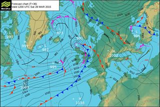
Met Office forecast chart for Saturday 28 March
On Saturday night and into Sunday more rain will spread across the country with strengthening winds. Sunday will start very wet and windy with heavy rain and gale force winds. The rain should clear later in the morning leaving a drier and brighter afternoon but still with showers. Temperatures will be around 10-12°C but it will feel cooler in the blustery wind.
Next week, there's more wind and rain on the way on Monday. It will turn colder on Tuesday and Wednesday but drier and brighter with a mixture of sunshine and showers. You may have read we may be in for a heatwave over Easter weekend but there's no sign of one. At the moment it looks rather cool with a few showers but there is a hint of high pressure which may bring some longer dry spells, some sunshine and lighter winds.
