
There was a brief window of dry weather and sunshine on Saturday but it didn’t last, with yet more heavy rain, showers and strong to gale force winds over the weekend. The highest gust recorded on Saturday was 75mph at Aberporth, Ceredigion and on Sunday 70mph at Aberdaron, Gwynedd.
There was hail and thunder in places and it was cold enough on Sunday for the showers to turn wintry with snow on higher ground.

Hailstones in the Elan Valley, Powys on Sunday afternoon. Photo by Paul Williams.
Looking ahead, there is more rain and showers to come this week as low pressure moves southwards into France. A little snow is likely on higher ground later on Wednesday as the wind turns into the east and it starts to turn a little colder.
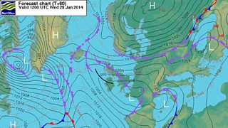
Met Office weather chart for Wednesday, 29 January 2014.
Thursday will be the coldest day of the winter so far with daytime temperatures ranging from 1 or 2°C on high ground and up to 4 or 5°C on the coast.
There maybe a few light snow flurries here and there, mainly in the east and northeast but on the whole a much drier and brighter day is on the cards. Some frost is likely and icy patches will be a hazard as temperatures fall close to freezing or below overnight.
Friday will start dry and cold but rain will spread from the west during the day. Some heavy rain is likely and it will also become windy. Temperatures will recover, rising to between 5 and 8°C, with gale force southerly winds for a time through the Irish Sea.
The unsettled weather looks set to continue into February with low pressure bringing further spells of wet and windy weather interspersed with clearer, colder conditions and blustery showers. The showers will be wintry at times, especially on higher ground.
You may remember that by this time last year we’d had some heavy snow but there is no sign yet of a repeat performance this winter, which is turning out to be very wet with no shortage of rain - and there’s more to come!