
In my last post I mentioned the uncertainty and difficulty in predicting the track that ex-hurricane Bertha would take over the weekend. We weren't 100% sure even on Friday but in the end Bertha did affect Wales, bringing heavy rain, thunderstorms and strong winds.
August is living up to its reputation of normally being the wettest summer month in Wales and in Cardiff, 47mm of rain fell in just 24 hours; about half the monthly average of 93.4mm!
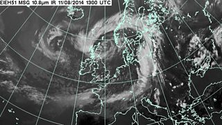
Satellite picture at 2pm on Monday 11 August. Image: Met Office
The highest gusts recorded on Sunday were 57mph near Capel Curig in Snowdonia and 52mph at Mumbles Head in Swansea. Mind you, we've had worse storms in August in the past and some of you may remember the Fastnet Storm in August 1979.
Low pressure Bertha is now over the North Sea centred between Norway and Scotland and will continue to dominate our weather this week bringing blustery winds and showers.
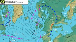
Forecast chart for Tuesday 12 August
Given sea temperatures are warmer than average at the moment, the air will be very unstable with towering clouds, heavy showers and a risk of hail and thunder.
Temperatures will be on the cool side and it may feel as if autumn has come early this year, especially at night, but out of the wind and in the sunshine it will feel quite pleasant.
On Friday there should be fewer showers and more in the way of dry and bright weather.
