
August in Wales was wetter and cooler than average.
It was the coldest August for 21 years breaking a trend since last November where every month has been warmer than normal.
But as soon as the school holidays ended the weather improved and so far September is making up for the disappointing August.
High pressure has brought plenty of fine weather and sunshine, a real bonus for the farmers and their harvest, and we’ve been treated to some lovely sunsets as well.

Newgale sunset captured by Sue Penberthy
The nights have been chilly with some morning low cloud and mist as you’d expect at this time of year but the afternoons have been bright and warm.
For example, Porthmadog and Eglwyswen reached 24°C today - well above the September average which is closer to 17°C.
Over the next few days, low pressure over the Bay of Biscay will move closer to the UK and this will drag in warmer south-easterly winds from the Mediterranean and France.
It will also turn increasingly humid with a risk of a few heavy showers and thunderstorms, especially on Friday.
Torrential downpours are possible but these are likely to be hit and miss which means some places will escape with next to no rain.
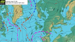
Forecast chart for Wednesday 17 September
