
1 June is the start of meteorological summer in the northern hemisphere. Although people often call it Flaming June we don't always get endless days of sunshine and soaring temperatures like we did during the heatwave summer of 1976. Sometimes it can be cool and wet, while in June 1975 (pdf) there was widespread snow!
June 2012 was exceptionally wet; more than double the average rainfall fell making it the wettest June since 1910 with severe flooding in Ceredigion.
During the spring and early summer east or north-easterly winds are fairly common in our part of the world. The jet stream weakens and areas of high pressure form over the sea.
However, the weather pattern often breaks down in mid to late June with the 'return of the westerlies' and low pressure can bring torrential downpours and flash floods.
Some people call this the start of the 'European Monsoon' but it's not like the monsoon in India, which is caused by a shift in the prevailing wind.
Tomorrow a trough of low pressure will bring some rain and showers, heavy in places, and it will be cool for the time of year as well with top temperatures of only 12 to 14°C.
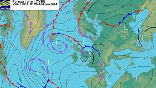
Forecast chart Wednesday 4 June
Thursday will be a better day; much drier with some sunshine, the odd shower here and there, and feeling warmer too with lighter winds.
Friday will start dry and bright but low pressure over the Atlantic will spread some rain northwards during the day. It will become breezy with a freshening south-easterly wind with top temperatures of 17 to 21°C.
The weekend will start humid with a risk of heavy showers and thunderstorms but then turn fresher. Some dry weather and sunshine is likely as well with maximum temperatures in the range 16 to 21°C.
Derek
