BBC BLOGS - Paul Hudson's Weather & Climate Blog

Archives for July 2011

Arctic Ice extent heads for satellite record low

Blog comments are currently unavailable. Find out more.

Paul Hudson |12:56 UK time, Monday, 25 July 2011

Exceptionally warm weather across the North Pole during the first half of July, with temperatures up to 8C above normal, could lead to record low ice extent this year according to experts, based on data collected by satellites which started in 1979.

Arctic sea ice is already lower than at the same time in 2007, shown below, the year which currently holds the satellite record for the lowest ice cover.


The continued decline in Arctic sea ice continues to confound climate sceptics who have consistently predicted a rebound from the low point in 2007.

According to The National Snow and Ice Data centre, sea ice is 23% below the 1979-2000 average.

My experience with solar panels

Blog comments are currently unavailable. Find out more.

Paul Hudson |13:05 UK time, Friday, 22 July 2011

I thought I might share a recent personal experience of mine. Having considered the idea of generating my own electricity by way of solar photo voltaic panels on my roof for the last few months, I have finally taken the plunge.

My house is directly south facing, so the roof is in a prime position for capturing solar energy.

I now have a roof with 16 solar panels - a 2.96 Kilowatt (kw) array, producing an estimated 2467 Kilowatt/hours of electricity (kw/h) in a year.

The government are so keen to encourage all of us to help them reach their legally binding target of generating 30% of electricity from renewable sources by 2020, that they have made the level of subsidy available to you and I really quite high.

The main subsidy is called the Feed in tariff (FIT), 43.3p Kw/h, index linked each year to RPI inflation, currently running at over 5%.

Next is the export tariff, at 3.3p Kw/h, index linked to electricity price inflation.

And this is the interesting bit. Because it is not yet possible to determine how much of the solar electricity you are selling to the national grid, and how much you are using, it is assumed that you are using 50%, and are paid for the other 50% by way of the export tariff.

But of course you can use as much of the solar power as you want. So by changing how you use your main appliances, you can in theory save even more.

This is how figures for my house stack up:

The cost of Installation, inc VAT at 5% came to £11,000.

In round figures I then receive £1100 per year in tariff payments, and save an estimated £150 on my electricity bills. That equates to a yearly income, index linked to inflation of £1250. An 11% tax free return.

This means that in just 8 years, my solar panels will have been paid for, leaving 17 years of tax free index linked returns, and much cheaper electricity bills.

So where does the money for such generous tariff payments come from?

Perhaps controversially, it turns out that every single one of us are paying by way of a hidden levy on our electricity bills, whether you take advantage of this scheme or not.

And if you can't afford to pay for your own solar panels, there are numerous companies who will fit them for free. They pay for this by taking the feed in tariff and export tariff themselves, leaving the householder free to use any electricity generated.

But as impressive as the figures are, there are a couple of points to bear in mind when choosing from the ever growing number of companies in the solar power sector.

A Which? report earlier this month found that some companies were offering customers misleading information.

For example the amount of sunshine available each year has been exaggerated in some instances, which in turn exaggerated the amount of electricity likely to be generated, and income receivable.

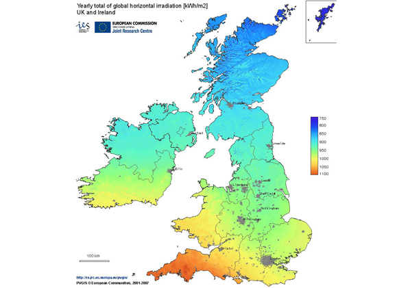
Some companies were quoting sunshine totals for Cornwall for other locations around the country which get much less sunshine. The figure for Northern England, and used by the Energy Saving Trust is 833 hours of sunshine each year, based on the solar irradiance map shown below.


Also worth pointing out that some companies will quote a higher figure of electricity savings such as 70%, which again would increase the savings on electricity bills, rather than the industry standard 50%.

Finally, this is a long term investment - so check that the panels come with a 25 year warranty - which will come into play should the performance drop below 80% of total output - and that if the solar panel manufacturer goes bust - the warranty is insured.

Follow me on twitter @Hudsonweather

Rest of July heading for a washout

Blog comments are currently unavailable. Find out more.

Paul Hudson |14:58 UK time, Thursday, 14 July 2011

Most parts of the country have enjoyed a fine summers day today, with plenty of sunshine.

But although it's the last thing the UK tourist industry wants to hear, the message is enjoy it while it lasts.

By the weekend low pressure will again be dominating our weather as the jet stream moves further south than normal, as it did for much of June.

The two charts below, the first for this sunday and the second for a week on sunday are typical of what we can expect for much of the rest of July.


The atmosphere will be stuck 'in a rut', leading to spells of rain, interspersed with brighter days, but with a risk of heavy, thundery showers.

During spells of weather like this it's not all doom and gloom. Two or three fine, dry days on the trot are possible, but rain bearing clouds will never be far away.

At least the rain will continue to alleviate the drought conditions in eastern areas.

As I indicated on this blog in May at the end of our gloriously warm and sunny spring, that although it was possible that the fine weather would last through summer, a more likely scenario based on historical weather records was for summer to turn unsettled.

Once more, so far at least, climatology has proved to be a very useful tool in predicting what summer is going to be like.

Climate records also indicate that should the rest of July turn out to be unsettled as expected, more often than not August remains changeable, although there are exceptions to the rule.

Let's hope this year August is one of those exceptions - if not, September could see a big improvement.

Global temperatures: Up sharply in June.

Blog comments are currently unavailable. Find out more.

Paul Hudson |17:10 UK time, Thursday, 7 July 2011

The latest global temperature has been released and according to the UAH satellite measure June's anomaly was 0.314C above the running 30 year mean, up from +0.133C in May

Adjusted to the more standard time period used by the Met Office and the WMO, the anomaly is now +0.567C above the 1961-1990 average.

All parts of the globe experienced a rise in temperature, and as can be seen below, global temperatures have rebounded sharply in the last 6 months from the minimum at the turn of the year, at least on this satellite measure.

Unsettled June weather to extend into July

Blog comments are currently unavailable. Find out more.

Paul Hudson |15:30 UK time, Monday, 4 July 2011

Despite the warm and sunny conditions in the last few days, the unsettled weather which plagued much of June looks set to return.

June turned out to be wet across the UK, dominated by low pressure. Averaged across England & Wales, 122% of average rainfall was recorded.

In our region, for a change, the highest rainfall figures were in eastern areas, where rain is needed most.

For example at Coningsby, in drought order hit Lincolnshire, 77mm of rain was recorded, compared with the average of 54mm - 143% of the average.

In Skipton 73mm of rain fell, compared with their average of 77mm; at Dishforth 52mm of rain was recorded, very close to their long term average for June.

It was also the coolest June for 12 years, based on Central England Temperature data.

The ridge of high pressure which has produced fine & warm conditions in the last few days is starting to give way, and later tomorrow low pressure will be firmly back in charge of our weather.

There will be some rain for most areas in the following week or so - quite often in the form of showers, some of which will be heavy and thundery, so there will be some drier brighter spells in-between.

The weather chart below for Friday indicates unsettled conditions across the whole of the country.


The jet stream which controls our weather is to blame, once again positioning itself to the south of the UK.

It's still early days, but with the half way stage of summer approaching, so far only Piers Corbyn at Weather Action can claim any success with this summer's forecast.

He argued consistently that Summer 2011 would be unsettled because of, in part, continued weak solar activity, which would at times push the Jet stream further south than normal.

Longer term, heading towards mid-July, there are signs that although westerly winds will dominate, pressure may build in southern areas, leading to traditional set up across the UK.

This would mean the driest conditions would be in more southern and eastern parts of the UK, with most rainfall in more northern and western areas.

This is exactly the type of weather pattern that is most common across the British Isles at this time of year.