BBC BLOGS - Paul Hudson's Weather & Climate Blog

Archives for July 2010

Global temperatures: Set for a sharp fall?

Paul Hudson |12:59 UK time, Wednesday, 21 July 2010

Blog comments are currently unavailable. Find out more.

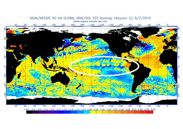
The El Nino which has helped to cause near record global heat so far this year is now history, as sea temperatures in equatorial regions of the Pacific continue to fall. The following 2 images illustrate the change the has occurred over the last few months to sea surface temperatures in the Equatorial region of the Pacific.

elnino.jpg

lanina.jpg

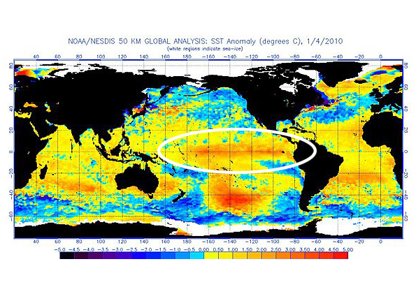
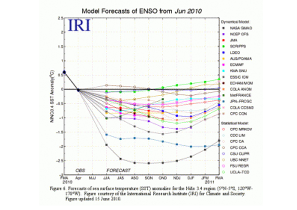
Most models, as you can see below, now predict La Nina conditions (SST anomalies less than or equal to -0.5oC in the Nino region) to develop during through the rest of summer and to continue into 2011 causing a sharp cooling of global temperatures later this year and into next.

model.jpg

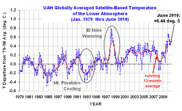
Just how fast will be crucial in deciding whether 2010 will be hotter than the hottest year on record, which was set in 1998, as defined by the UK Hadley Centre, The World Meteorological Organisation (WMO) and UAH Satellite data.

During a La Niña, trade winds in the western equatorial Pacific are stronger than normal, and the cold water that normally exists along the coast of South America extends to the central equatorial Pacific. This colder water directly translates into colder global temperatures, just as warm waters associated with an El Nino directly translates into warmer global temperatures.

The Last El nino comparable to this one in 1997/1998 was followed by a La Niña which began developing in the middle of 1998 - and was persistent into the winter of 2000. According to the Japanese institute for Marine Earth Science, the La Nina condition developing now might last for a longer-than-normal period.

If history repeats itself, not only could 2011 be much cooler than 2010, but that cool bias could extend into 2012 too.

globtemp.jpg

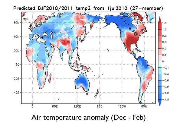
The picture above illustrates how their global model sees the world surface air anomalies between Dec 2010 and Feb 2011. Note on average how much of the land is actually cooler than normal by that time.

First half of 2010: Close to record warmth (UPDATED FRI 7th JULY)

Paul Hudson |17:36 UK time, Thursday, 8 July 2010

Blog comments are currently unavailable. Find out more.

UPDATE at 1200 Fri 9th July

The last paragraph of my latest blog seems to have aroused interest so for clarification this may be of interest.

I spoke to various people in climate science when I put together my article 'global temperature predictions for 2010'. One prominent climate sceptic told me that there was no chance of 2010 being warmer globally than 1998 because of solar considerations. 1998, from a solar point of view, 'was a coming together of many things' he said, that would not be replicated possibly 'for another 100 years'. He went on to admit that if 2010 was hotter than 1998, he may have to re-examine his theory that it was the sun that was the main driver of global temperatures.

ENDS


There's been some hot weather across some parts of Europe and America in the last few days.

The eastern US and parts of Canada are in the grip of a heatwave with soaring temperatures are affecting areas from Quebec to Virginia; the mercury hitting 39.5C (103F) in some places. Power cuts have occurred as energy usage soars, leaving thousands of households without power

Eumetnet, the public European weather services network within the World Meteorological Organization, has issued severe hot weather warnings for most of Spain, the western half of Germany, most of Belgium and parts of the Netherlands.

Temperatures in Berlin are expected remain at highs of 35-36 degrees Celsius until Monday, before cooling slightly in the middle of next week, according Germany's national forecaster, while Madrid is melting at highs of 40 degrees on Thursday, according to Spain's official forecaster, with highs of over 34 degrees into next week.

Here in the UK, the Met Office warned there was a 60% chance that somewhere in the Southeast could reach 32C for the first time this year.

From a global perspective, temperatures have been close to record levels in the first 6 months of the year.

The graph below shows that temperatures seem to have peaked very close to the values reached during the hottest year on record set in 1998.

GLOBAL.jpg

In the first 6 months of this year, average global temperature anomalies according to satellite data were 0.565C above normal, compared with the first 6 months of 1998, when the figure was 0.64C.

The difference between the two is not statistically significant.

Met Office data also shows that global temperatures in the first half of 2010 have been close to record levels.

Global temperatures are expected to fall later this year, as El Nino fades fast, possibly replaced by La Nina conditions. Just how fast they fall will be critical in deciding whether, as the Met Office forecast late last year, 2010 becomes the hottest year on record.

A similar drop was experienced during the second half of 1998; 1999 was a cooler year and it is likely that 2011 will be cooler than 2010, too.

All this comes against a background of a continued very weak solar cycle which has gone on far longer than normal.

Those who believe that the sun plays a much bigger role in governing the level of global temperatures (as opposed to how it might affect weather patterns) could be forced to re-think their beliefs in the face of these high worldwide temperatures which are being measured by both conventional land and sea-based thermometers, and satellite data alike.

Have we seen the best of Summer already?

Paul Hudson |15:53 UK time, Thursday, 1 July 2010

Blog comments are currently unavailable. Find out more.

At Leeming in North Yorkshire, mean maximum temperatures for June came in at 19.9C, almost 2C higher than the June average. That makes it the warmest June since 2006. Sunshine was well above average, but with rainfall only just below the average coming in at 48.2 mm (Average 54.5mm).

Across the UK it has been the driest first 6 months of any year since 1953.

And according to preliminary CET (Central England Temperatures) figures, it has also been the warmest June since 2006.

Looking back through the climate records, one thing stands out. Long periods of dry weather in Spring and early summer often means the rest of summer is much more unsettled. There are exceptions to this rule, like in 2003 and 1976 to name but two, but the odds are stacked against a continuation of dry and warm weather through the rest of summer.

And there is a reason for this.

The Jet stream, a ribbon of strong winds in the upper atmosphere, controls our weather and is responsible for Atlantic depressions and areas of high pressure, leading to wet and dry weather respectively.

The Rocky Mountains in North America act as a barrier to the jet stream, and as air blows across the mountain range, a series of waves are produced downstream.

When the jet stream is at its strongest, the waves pushing eastwards from this mountain range are flat. This is what we call a 'mobile westerly' with weather systems bringing rain, followed by a couple of days fine weather, and then another weather system, and so on. Typical British weather in fact.

But when the Jet stream is at its weakest, the waves are shorter, causing a series of much more pronounced peaks and troughs in a much more 'meridional' or north-south pattern.

In this situation, a ridge of high pressure can get stuck over the UK, leading to persistent dry weather, which is what we have had for the last few months. Conversely when a trough becomes established we can have weeks of wet weather.

Interestingly, the wavelength of these peaks and troughs in our atmosphere tends to get shorter as we head into summer. So if a ridge (dry weather) has dominated our weather in spring and early summer, it is likely to move westwards into mid-Atlantic, leaving the UK under trough (unsettled) conditions. And as we head through early July it is common for this weather pattern to remain for the rest of July and August.

Currently the pattern is certainly shifting, as the upper trough starts to position itself across the UK in the next few days, with weather systems bringing rain in from the west in a more typical mobile-westerly set up.

It's for this reason that the weather is expected to be much more unsettled during the first half of July. Only time will tell if this change will last for the rest of summer.