What can you see on a map?
A map is a two-dimensional drawing of an area. Maps can show the countryside, a town, a country or even the whole world. They can be on paper or on a mobile phone, tablet or computer.
People use maps to help plan routes from one place to another. They might also use a map to find certain features like hills or rivers, or a landmark such as a castle.
You can use different types of map depending on whether you are walking, driving or even flying somewhere.
Watch: Maps with Sue Venir
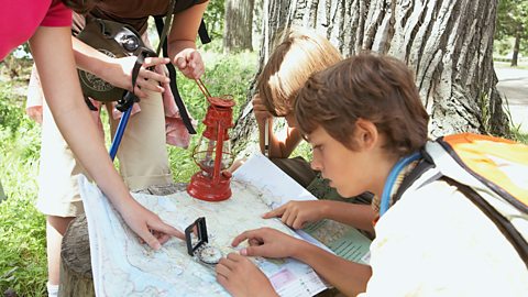
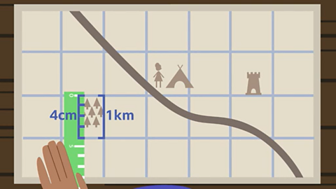
I’m hiking in Shropshire. I’m planning my route using this map. I’m working out how far it is to this castle and which way it is. I’m here by the campsite.
First I need to find out which direction the castle is in. For that I’ll need a compass.
A compass shows four main directions, or points: north, east, south and west.
The thing wobbling around in the middle there is the needle!
The needle always points north and the top of the map is north. I can see the castle is east of where I am! So the castle must be… That way!
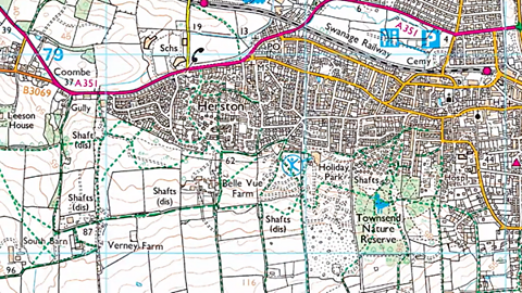
Now, I need to know how far it is.
A map is a two-dimensional drawing of an area. The scale on a map shows how many times bigger the real world is than the map.
So, four centimetres on this map, is one kilometre in real life.
So I can see that the castle is two kilometres from where I am.
I like old paper maps, but we can also use maps on our phones or tablets. Which is just as well!
How do you use a map?
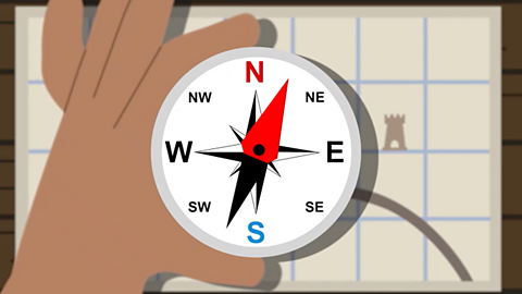
The top of most maps is north and a compass can be used to find which direction north is. The needle of the compass always points north, so when it is lined up with the map, you can see in which direction things are.
The four main compass or cardinal directions are: north, east, south and west. The four points exactly in between each of these, are: north-east, south-east, south-west and north-west.
Maps are not drawn to the same size as the ground because they would be far too big. Instead they are drawn to a smaller scale.
The scale on a map is a set of numbers that can be used to compare distances and can be written, for example, as 1:25,000.
This means that the actual size of the ground is 25,000 times bigger than it is on the map.
The same scale can also be written as 4cm to 1km, so every four centimetres on the map is one kilometre in real life.
Watch: Navigating and living in the UK
Learn more about map-reading in the UK in this video from BBC Bitesize for Teachers.
De-Graft: The United Kingdom of Great Britain and Northern Ireland, or the UK as it’s known, is made up of different countries, communities, and environments. There are loads of things to see and places to explore – for example, did you know, that there are more than two thousand miles of canal towpaths?
This is Manchester. Here waterways or canals were once the main way of transporting raw materials and trading goods, but now they’re used primarily for leisure.
Later, locals Haniyah and Lola will be helping me understand a lot more about using a map to navigate around the UK. But first, let's zoom out.
I’m here in Manchester, one of the biggest cities in England. The UK is made up of four countries: England, Scotland, Wales and Northern Ireland, which can be found on the two largest islands within the British Isles. The biggest island is called Great Britain, which contains England, Scotland and Wales.
The UK is made up of different communities, rural and urban, that are distinct and have unique traits. As you can see on this puzzle, in England the country is divided into different areas called counties. In Northern Ireland there are districts, Wales there are principal areas, and in Scotland there are council areas.
We call all the places that people live in ‘settlements’, and there are a few different shapes and sizes. A hamlet is a very small settlement, with just a group of houses. A village is also small but as well as houses, there may be a shop, a school, a place of worship or a village hall. A town has all of the same features as a village but there may also be a railway station, a shopping centre, more places of work and places of worship. A city is even larger. Cities have a lot of housing, schools, universities, hospitals, offices, and often a cathedral. And a megacity are when a number of large towns and cities combined to create a massive urban area.
OK, time to compare. Across all of the settlements in the UK, in England, Scotland, Northern Ireland and Wales, there’s a total population of over 66 million people spread out over 242,500 square kilometres.
The USA has around five times more people, living in an area of over nine million square kilometres.
Looking at maps is a great way of spotting settlements and locals Lola and Haniyah have joined me on the outskirts of Manchester to have a go.
So guys, what do you make of this view around us?
Lola: I think it’s really nice, it’s got lots of buildings.
Haniyah: I think it’s a nice, calm, relaxing view.
De-Graft: We’ve got all the nice scenery behind us but in front of us we’ve got a big, old map. What kind of things do you use maps for?
Lola: It tells you how to get to places or where places are.
De-Graft: Absolutely right! Maps are two-dimensional drawings of an area, and they can be digital, like on our phones, or on pieces of paper. But we don’t just have a map in front of us, we’ve also got a compass. Haniyah, can you grab the compass and show us where north is?
Haniyah: So north, if I point the compass like that, would be facing there.
De-Graft: Very nice work. Maps are drawn to a much smaller scale so they can fit everything on a piece of paper. So, the map we've got in front of us is a 1:25000 scale map. That means every four centimetres on the map is the same as one kilometre in reality.
Now I’ve got a bit of a challenge for you guys. I need you to get your rulers to tell me how far is Salford Quays from Manchester City Centre.
Haniyah: 12 centimetres but in real life it would be three kilometres.
De-Graft: That’s right, three kilometres ‘as the crow flies’ or if you were to draw a straight line.
So why don’t you have a go at map reading and plan some local routes to some nearby places. Zoom in and have a go for yourself.
Right guys, where are we off to next? Cool, let’s go!
Activity: Quiz – Using a map
Race Across the Continents game - new update! game
Help this team of adventurers race their way to victory. Explore the globe in this exciting game update to discover new audio voiced by Ade Adepitan and fun animations. Challenge yourself with brand-new achievements and become a high-flyer!
More on Geography skills
Find out more by working through a topic
- count5 of 10
- count6 of 10

- count7 of 10
- count8 of 10