13 November 2014 |

| |
BBC Homepage | |||
Contact Us | |||
WalksYou are in: Somerset > Entertainment and Leisure > Nature > Walks > Walk The Coleridge Way 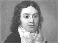 Samuel Taylor Coleridge Walk The Coleridge WayWalkers can now follow in the footsteps of romantic poet Samuel Taylor Coleridge by taking a route from Nether Stowey to Porlock. You can retrace the poet's footsteps from the Quantocks to Exmoor on the 36-mile route. The Coleridge Way takes you close to the isolated farmhouse where he wrote Kubla Khan, and follows paths and bridleways through the villages of Holford, Bicknoller, Monksilver, Roadwater, Luxborough and Wheddon Cross.  Points West's Amanda Parr on the walk Short diversions from the main route take you to the tiny church at Culbone (the smallest complete church in England) and the Bell Inn at Watchet, where legend says Coleridge started his most famous work, The Rime of the Ancient Mariner. Help playing audio/video Samuel Taylor ColeridgeBorn in Ottery St Mary in Devon in 1772, Coleridge is one of England's most famous poets He moved to Nether Stowey in 1797, with his wife Sara and their son, and was joined in Somerset by William Wordsworth and his sister Dorothy, who rented a house in Alfoxton Park. The family lived at the cottage for three years. Coleridge wrote some of his finest poems there: Fears in Solitude, This Lime-Tree Bower my Prison, The Nightingale, Frost at Midnight, the first part of Christabel and The Rime of the Ancient Mariner, which has many references to neighbouring places. 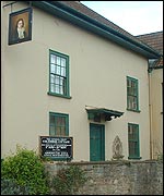 Coleridge's Cottage in Nether Stowey Coleridge published The Rime of the Ancient Mariner as part of the Lyrical Ballads poems with Wordsworth. Together, the two poets were largely responsible for inaugurating the Romantic Movement in England. You can see photos and listen to audio clips of Nether Stowey and Coleridge's Cottage by clicking on the links at the top of this page. The Coleridge WayThe trail is suitable for walkers of all levels and abilities. There are plans for the route to be developed for horse-riders and cyclists as well. You can find out more, and get a printable map and directions by following this link: The Coleridge Way (marked in green below) was developed by West Somerset and Sedgemoor District Councils, Exmoor National Park Authority, Quantock Hills AONB Service, Art Life and Somerset County Council. The BBC is not responsible for the content of external websites 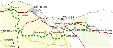 Somerset County Council. Based upon Ordnance Survey mapping with the permission of the Controller of Her Majesty's Stationery Office Crown Copyright ©. Unauthorised reproduction infringes Crown Copyright and may lead to prosecution or civil proceedings. Licence No. LA07683X. Map not reproduced to scale. last updated: 26/02/2009 at 17:39 You are in: Somerset > Entertainment and Leisure > Nature > Walks > Walk The Coleridge Way [an error occurred while processing this directive] |
About the BBC | Help | Terms of Use | Privacy & Cookies Policy |
