 |  | | | Ground Deformation | | 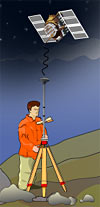 | | 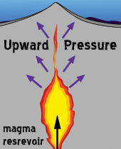 | | Upward pressure from rising magma deforms the volcano. |
| Pressure from rising magma deforms the volcano. The ground can change shape by rising up, subsiding, tilting, or forming bulges. Scientists monitoring an active volcano will often measure the tilt of the slope and track changes in the rate of swelling. An increased rate of swelling is a sure sign of an impending event.
The newest and most accurate system of measuring ground deformation is the Global Positioning System (GPS). This involves using a number of satellites and radio waves. A receiver is set up close to the volcano then data can be transmitted between satellites orbiting the earth and the receiver. Data is obtained in just a few minutes and is extremely accurate. | | Another method involves measuring tiny changes in the slope angle or "tilt" of the ground with tiltmeters. An electronic tiltmeter is very accurate and can detect tiny changes in the slope. Five electronic tiltmeters record ground deformation around the flanks of the Soufrière Hills Volcano. |
| |  | | |
|
