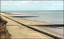
DISTANCE: 5.5 miles. MAP: OS Landranger 133 North East Norfolk. STARTING POINT: Walcott Gap (GR 359329). GETTING THERE: From the A149 Great Yarmouth-Cromer road ½ mile west of Stalham take a road signed Bacton 8, Happisburgh 5. At a T-junction turn left, signed ‘Walcott 4½ Happisburgh 4½ Bacton 7½ . Follow this road until it reaches the sea at Walcott. There is parking on the right for a few cars at this point. Should this be full, you can park on the roadside a few yards further on. ALTERNATIVE STARTING POINT: If you want to visit the teashop at the beginning or end of your walk, start at the beach car park at Happisburgh. To find the teashop, return to the road and turn left for a few yards. You will then start the walk at point 9. THE WALK
Please note: there have been many official path diversions in this locality and the paths on the ground are not as shown on the OS map. 1. Walk back along the road for about ¼ mile. 2. Just after a road on the left, signed ‘Coastline Village’, take a path on the right to continue in the same direction, parallel with the road. After ¼ mile the path crosses the road to continue in the same direction, still parallel with the road. At the lighthouse walk in front of the pub and continue ahead to a church, usually locked. 3. Cross the churchyard and turn left on a path on the far side of the church. Follow the path out of the churchyard and straight ahead across a field, in the direction of a farm, to a lane. 4. Turn right and walk along the lane for 1/2 mile, crossing a road. 5. At a road junction with a lane on the right, turn left on a less-than-obvious path, initially between farm buildings and then to the right of a bank. When the bank ends at a wind-bent tree, continue along the strip of grass between fields for about 80 yards and then bear diagonally left across a field towards a church, crossing a ditch at a plank bridge. (The exact line of this path varies from year to year). Look for a power line supported on three poles at the far side of the field. The bridge is about 15 yards to the left of the middle one. Over the bridge continue in the same direction across the next field to a lane at a road junction. 6. Turn right along the lane. 7. About 140 yards after Kiln Cottage take a signed path on the left level with a small building surrounded by a wire fence a field away and walk across a field in the direction of the lighthouse. Continue along the right-hand side of two more fields to a surfaced path beside a lane. 8. Turn left and then right along Beach Road, passing the entrance to a public car park, to the teashop on the left. 9. Take a track next to the teashop and at a T-junction turn left behind some clifftop chalets. 10. At a lane turn right for a few yards to a lifeboat station then left on a path on top of the cliffs. Follow the path past some disused coastguard buildings. 11. When one field away from the chalets of a holiday complex and level with a small building surrounded by a wire fence a field away to the left, the path ahead goes through a low bank. Do not go through the bank but turn left to walk with the bank on your right to this structure. Turn right along a track to a lane. 12. Turn right and follow the lane round a left-hand bend, then a right-hand bend to a second left-hand bend. 13. Take a track on the right to continue in the same direction to reach the coast. Turn right down a concrete ramp then left along the shore, back to the start. From Teashop Walks in East Anglia by Jean Patefield, published by Countryside Books, £6.95. |