You are in: Manchester > Nature > Walks > The Kirklees Valley > Stage 1
The Kirklees Valley
The Kirklees Valley
With the coming of the Industrial Revolution The Kirklees Valley landscape changed with the building of mills. Now much of the area is being reclaimed by nature.
Walk details:
Start point:
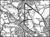
Kirklees Street, Tottington, Bury
Countryside Rangers' office:
Bury Countryside Ranger Service, 0161 253 7984
Ordnance Survey:
Explorer 287 - map ref: SD780130
Distance:
approx 2km (1.2 miles)
Time:
approx 1 hour 15 minutes
Extra info: To see what the symbols mean, please visit the key
More info: This walk takes you along the route of the old railway line at Tottington and through the site of the former Tottington Mill Printworks.
You will have plenty of opportunities to learn about the local landscape and find out how this one time tropical swamp has, over millions of years, changed and how more recent industrial developments have impacted on the area today.
Getting there: By bus: From Bury get the 469 to Tottington Bus Terminus. By car: Drive to start point, (see map). Parking on roads - Kirklees Street and South Royd Street.
Walk conditions The disused railway line is flat with an all weather covering.
There are a number of gates along the old railway line that are wheelchair and buggy friendly.
All gates have RADAR locks fitted. Away from the disused railway line paths are variable. Some are cobbled, uneven and will be muddy and slippery when wet.
Due to the nature of the area, caution is needed close to mill ponds and on non-established paths.
Please note - some parts of this walk may not be suitable for wheelchairs.