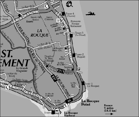
Start Point: La Rocque Harbour car park, Grouville.
Distance: approx 2 miles
Time: approx 1 hour
Walk Conditions:
There is no footpath for the majority of the walk circuit, although the lanes and roads are relatively traffic-free.
The walk for the most part is flat with a slight upward incline as you head inland from the harbour.
Those who choose to walk on the beach and fully explore the harbour area may need to negotiate uneven slipways, steps, ladders, sand, pebbles and rocks. Conditions on the beach will vary according to tide and weather. Waterproof footwear is advisable.
![]() Head along the car park to the phone box. At this point cross the road and head inland on La Rue du Pont. To explore the harbour area, see the last step in the walk.
Head along the car park to the phone box. At this point cross the road and head inland on La Rue du Pont. To explore the harbour area, see the last step in the walk.
La Rue Du Pont cuts through an agricultural plain which was enriched by loess that blew across from what is now France during the Ice Age period (Jersey would not have been an island at that time). This rich soil not only supports the crops of today but was also used for brick making in the 19th century. Fossilised shells and snails have been found in local loess and can be seen at La Hougue Bie in St. Saviour.
Before the Chapel you will pass the site of the now long-gone La Rocque Railway Station which formed part of the Eastern Railway that ran between St. Helier and Gorey until 1929. A fireplace, set into a wall on the left side of the road bears the name 'Place de la Gare' meaning Station Place. The Anglican Fisherman's Chapel of St Peter La Rocque is the second church in the Parish of Grouville with services taking place once a month.
Most noticeable along this stretch of the walk are the 'Happy Hens'. These hens are free to roam in their large enclosure, which regularly moves around the field. With a broad field of vision here you may see many species of birds including birds of prey hunting and feeding in the area. Further on you will pass Clos Des Pauvres. This field was given to the parish in 1849 so that its rent proceeds could be given to the poor. A large inscribed stone marks this donation.
![]() Once you have reached the crossroads, turn right into La Rue de Fauvic and then first left into La Rue du Parcq. At the junction with La Rue de la Marais a La Cocque turn right and follow this lane to the end when you will reach the main coast road.
Once you have reached the crossroads, turn right into La Rue de Fauvic and then first left into La Rue du Parcq. At the junction with La Rue de la Marais a La Cocque turn right and follow this lane to the end when you will reach the main coast road.
Just after the crossroads you will see a fine example of local 19th century architecture in the form of Fauvic Farm. The 'marriage' or date stone above the door gives the initials and date of the couple for whom it was built.
After crossing the road, the high wall which runs along the left side of La Rue du Parcq has a good quantity of small ferns and thick moss betraying the moist conditions. Moss provides many birds and animals with excellent nesting material.
At the junction with La Rue de la Marais a La Cocque you can't fail to see the lavoir and water pump which were restored in 2000. Lavoirs were public washing facilities which were governed by local laws as to their correct use. Protecting clean water supplies has always been important in Jersey!
Further along the lane there is an opportunity to see Jersey pure breed cattle at pasture - no cattle have been imported into the island since 1763 making them one of the most desirable and famous dairy herds in the world. A little further on, to the right, a short stretch of the Eastern Railway's route has been preserved as a shady footpath.
![]() Now you have joined the main coast road, head south along this stretch until you have an open view of the sea; you are now at Le Hurel.
Now you have joined the main coast road, head south along this stretch until you have an open view of the sea; you are now at Le Hurel.
After following the main road south you will reach the coast again at Le Hurel. This area of Jersey's coast forms part of a RAMSAR protected wetland which stretches from Gorey to La Collette. In this area, oysters, mussels and ormers are grown and harvested as part of the local shellfish industry. At low tide it is possible to see the beds and to watch harvesting in progress.
If visibility is good, you may be able to see the coast of France on the horizon. Until about 6,000 BC Jersey was still part of the European land-mass. If sea levels continue to rise as part of global warming it is easy to imagine that the part of Grouville you are now standing in would vanish beneath the waves; the land at this point being less than 40 feet above sea level.
![]() The short journey from Le Hurel to Seymour slip can be made either on the beach or by following the main road.
The short journey from Le Hurel to Seymour slip can be made either on the beach or by following the main road.
Road: You will pass behind two of Jersey's Round Towers; usually but wrongly called Martello Towers, these coastal defences were built to protect the island from French invasion in the late 18th century. True Martello Towers are shorter and smoother in design, a good example being Kempt Tower at Les Mielles in St. Ouen.
Beach: From the beach you should have an excellent view of Mont Orgueil and Grouville's line of coastal defences comprising Forts William and Henry and a line of four Jersey Round Towers. About a mile from the coast stands Seymour Tower which dates from 1782. It was built to defend the island from the French by the then Governor Sir Henry Seymour Conway, following the Battle of Jersey, in 1782.
![]() This is the last main stage of the walk, returning to the starting point of La Rocque Harbour. Should you wish to continue on the beach this is possible, but involves scrambling over rocks and small pools. If using the road, simply continue left from Seymour slip until you reach the harbour.
This is the last main stage of the walk, returning to the starting point of La Rocque Harbour. Should you wish to continue on the beach this is possible, but involves scrambling over rocks and small pools. If using the road, simply continue left from Seymour slip until you reach the harbour.
Walking back to the harbour you may see many species of migratory birds along the shore and on the rocks. Gulls, Ringed Plovers, Brent Geese, Shags and Oystercatchers are just some of the birds you may see.
As you reach the first slipway a plaque on the wall commemorates the lives lost in the bombing which occurred just prior to the Nazi Occupation of the island in 1940.
Once back at the harbour car park, on the land side of the road you will see an old cider press in a front garden which betrays our apple-orchard past. Until about 1830 Jersey is reputed to have been at least a quarter covered in apple trees, the fruit of which was turned into a valuable export: cider!
![]() Exploring La Rocque Harbour area is a walk through time in itself. From the western end of the car park follow the slipway down to the jetty to the end and back again.
Exploring La Rocque Harbour area is a walk through time in itself. From the western end of the car park follow the slipway down to the jetty to the end and back again.
In 1781 the site of La Rocque harbour, which was not in fact built until 1881, was the landing point of the invading French troops of Baron de Ruellecourt. The French were defeated by the local militia lead by Major Pierson at the Battle of Jersey in the Royal Square.
Most noticeable around the harbour area are the varieties of rocks. Most are granites, some dramatically veined by finer grained rocks such as aplite or pegmatite. The coarse texture and large grains of crystal in the granite tells us that it cooled slowly beneath the earth's surface before being eventually exposed by the elements.
Also visible from the west side of the jetty is Icho Tower offshore to the south. Another of Jersey's coastal fortifications it was built in the 19th century but can be reached at low tide on organised walks.