Walk Details:
Start Point: Corner of Eastgate Street/Brunswick Road (outside Argos)
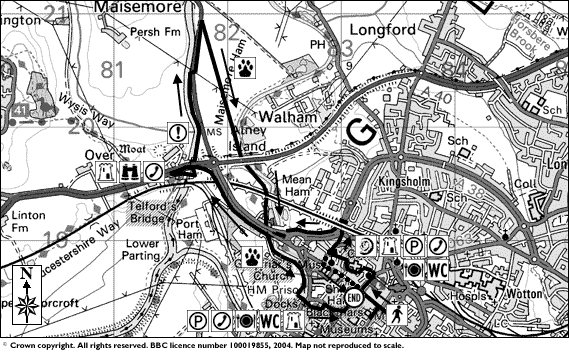
Ordnance Survey: Landranger 162 - ref SO 834-184
Distance: about 5-6km (3 miles)
Time: around 3-4 hours
Long Walk: The Gloucester Trail
This walk is the easier of the two routes because it follows a path around the centre of Gloucester, spotlighting building stones which hold significant natural history interest.
Requirements:
As the walk takes in countryside areas including stiles and dirt tracks, we recommend that boots and trousers are worn.
Walk Conditions:
The longer option which takes in Alney Island is slightly more difficult because there are a number of stiles and narrow foot bridge crossings on part of the route which would make it impossible to use wheelchairs or baby buggies. This route can also get a little muddy when wet so walking boots and trousers are recommended.
![]() The first point of interest is Argos Extra on the corner of Eastgate Street and Brunswick Road.
The first point of interest is Argos Extra on the corner of Eastgate Street and Brunswick Road.
The facing stones either side of the entrance are made from Shap Granite and feature some large Feldspar crystals that date date to the Devonian period some 390 million years ago..
Take a short walk down Brunswick Road and you'll see the City Museum on the opposite side of the road. Cross over and take a look at the walls of the building. These building blocks are made from Cotswold Oolitic limestone and feature some unique geological treasures such as vugs - pockets of crystals formed over millions of years. This stone dates back to the Jurassic period and the time of the dinosaur!
Head back to Eastgate Street and turn left. You will now see a large glass topped exhibition space just in front of Boots where you can see the medieval remains of the Gloucester East Gate.
Walk along Eastgate Street and look out for the Lloyds TSB bank on your right hand side. Closer examination of the stone here will reveal a pink/brown granite with more feldspar crystals embedded within. These granites are an example of igneous rock - rock which formed deep within the Earth.
Continue along the road until you reach The Cross. You'll notice a large church tower on your left - this is St. Michael's Church Tower. Check out the side nearest the Starbucks Coffee and you'll see more Oolitic limestone and an example of cross-bedding - this proves that Gloucestershire was underwater some 225 million years ago because cross-bedding is an example of tidal forces in action.
Head down Northgate Street you'll see a pub called the New Inn on you right. This pub dates back to the 15th Century and has some notable history. The Inn was home to a vast retinue of knights, gentlemen and yeoman who lodged at the Inn to pronounce the accession of Mary Tudor to the throne. Announcements such as this were usually made on The Cross, but in bad weather the Inn would have been preferable.
Continue along Northgate Street until you reach St. John's Church on your left. Take a left along St. John's Lane and follow the signpost for Cathedral Via Sacra. You should see a strange spire in front of you which rises about four metres from the ground - this is St. John's Spire and it's made from Cotswold Ragstone. This stone shows how the ragstone was susceptible to weathering over time.
Travel a short distance back the way you came and you'll see Cathedral Way Via Sacra - head down this passageway and you'll find yourself in front of Gloucester's historic cathedral. Approach the Cathedral and follow the wall around the corner to the left - now take a look at the limestone blocks at the base of the building. The sandy coloured stone is Oolitic limestone which was quarried in the nearby Cotswold hills. Again you'll see a great example of cross-bedding in the base stones.
Head into College Green (the area in front of the mani entrance) and move towards the buildings to the left of the main entrance gate. If you examine the pavement outside Nos 3 and 4 you'll see two distinct patterns on their surface. The patterns are a snapshot of the surface of the Earth around the Forest of Dean about 300 million years ago and, again, they tell of an area beneath water. The linear patterns are believed to have been made in river beds where water flows in one direction while the more erratic patterns are oscillation ripples which were formed by ebb and flow of the tide.
Now move over to the Cathedral and go inside. Head over to the choir altar and look at the brown/pink step just beyond the rope. The step is crammed full of crinoids - these were creatures which lived on the sea bed some 200 million years ago. Go into the Cloisters via the East Door and follow the passageway around - you might be interested to know that these corridors were the location of Hogwarts School of Witchcraft and Wizardry in Harry Potter and the Chamber of Secrets. Head out via the East Door and back into the main chamber of the cathedral. Facing the West Door, take a look at the memorial plaques to the left of the door - the centre one is a monument to Charles Rudhall and, if you look closely, you'll see it's crammed full of brachiopods. These shellfish lived during the Silurian period some 400 million years ago.
Head back out into College Green and follow the pavement around to the right. Head through the archway to the right. You're now in Miller's Green. The wall just by the telegraph pole has a wide range of stones from vastly different time periods and there's also a rock in the path that was from a volcanic explosion!
Return through the archway back into College Green and take a right. Head through another archway and you should see a grand monument to Bishop Hooper in front of you - this unfortunate soul was burned at the stake in 1555 right in front of the cathedral. Beyond is church of St. Mary-de-Lode.
Cross the road at the VW garage and follow the pavement around to your left. Head under the railway bridge and use the walkway on your right to cross to the other side. Once on the other side, head right. Follow the footpath along the dual carriageway until you reach the Westgate Leisure Area - this stretch about half a kilometre in distance. Follow the footpath around and underneath the right hand road bridge. Take the footbridge in between the two roads and then turn left, walking beneath the left-hand road bridge. Turn right and follow the A417. What follows will be a walk of about a kilometre alongside the road.
Following the busy road around to the left, followign the A40 to Ross. You should reach another road bridge over the River Severn. As you cross it you should be able to see a 19th Century stone bridge to your left - this is the famous Over Bridge build by Thomas Telford. Follow the road and take the first path on the left after the road bridge, which should lead you up on to Over Bridge.
Cross Over Bridge to the other side and you're now on Alney Island. About a mile above Gloucester the River Severn divides into two smaller channels and these unite below the city, forming the parcel of land called Alney Island.
At certain points during the year you can witness one of nature's great shows - the Severn Bore. The Bore is basically a tidal wave that forces its way up the river against the current, creating a large wave. It's a natural phenomenon that occurs in the lower reaches of a few rivers throughout the world.
The banks of the Severn along this stretch are home to a variety of creatures. You can see many species of birds including river dwelling birds like ducks, swans, snipe and moorhen. Magpies, swallows, robins and other birds frequent this area too.
Continuing up the Severn Way, you'll reach the end of the pathway - there's a stile on your right. Cross with caution though because there's a busy road on the other side. Once you're safely on the other side of the road, head left along the pavement beneath the electricity pylons. Continue along the road for about 200 metres and look for a footpath on your right - it isn't signposted but it'll be clear when you see it. Join this footpath to begin the Alney Island stage of the walk.
![]() After leaving the footpath by the road you'll find yourself following a diagonal path to your right across the fields. During much of the year this field will have wheat in it. A short way along the hedge to the right hand side of the field, you'll see a small raised platform that gives you access to the next field. The hedge itself is also something of a wildlife treasure trove with a wide variety of insects, birds and plants making their home within.
After leaving the footpath by the road you'll find yourself following a diagonal path to your right across the fields. During much of the year this field will have wheat in it. A short way along the hedge to the right hand side of the field, you'll see a small raised platform that gives you access to the next field. The hedge itself is also something of a wildlife treasure trove with a wide variety of insects, birds and plants making their home within.
After crossing the small footbridge you will now be in a grass field. Again you should see a diagonal path crossing it. One creature to keep an eye out for here are pheasants - they remain very still in the long grass and suddenly fly off in a panic if you get too close.
From the grass field you'll reach a hedge with another stile in it. After crossing you will find yourself in another field. The dirt path across this field is very clear and easy to follow. During the last ice age (Devensian - between 10,000 and 500,000 years ago) the area would have been quite something to behold. A huge ice sheet would have covered Britain as far south as Gloucestershire so, looking north during that time you would have seen the huge ice sheet in the distance.
Crossing through a stile you'll find yourself in another field. Follow the path through this one towards the electricity pylons. Passing beneath them you'll find you've moved into another field - during parts of the year you can see a maize crop throughout much of the year.
Leaving the maize corridor you'll find yourself on the bank of the East Channel of the Severn - you've just crossed from one side of Alney Island to the other. If you're really lucky you'll see the odd dragonfly flitting between the crop and the river. Follow the path along the river bank to your right and you'll eventually reach a stile. Please note that there are sometime cattle grazing in the next field. Once you've crossed over, follow the river around underneath the bridges and you'll reach another stile. After crossing this stile you'll find yourself amongst some trucks and caravans. Head to your left and follow the road straight ahead. Keep on going until you reach the end of the road and then take a left. Follow the footpath around and to your right. You will find that you're now heading under another road bridge. Keep to the left and head out the other side, still following the river. If you look left at this point you should see the cathedral on your left.
After crossing another stile, you need to follow the path across some wet grasslands. Again, the pathway skirts the East Channel of the River Severn. These wet grasslands are also a haven for wildlife.
Alney Island was also, possibly, the scene of an important medieval battle. The Anglo-Saxon Chronicle records that the Danish king, Cnut, fought and defeated the English king Edmund Ironside there in 1016.
Following the grass path you'll eventually reach the beginning of a tarmac pathway. Take a left here and cross the footbridge over the East Channel of the River Severn. You're now approaching Gloucester Docks and the final stage of the walk.
![]() From the footbridge, cross the road and follow the building in front of you around to your left. Pass through the white gates on your right. You should now get your first glimpse of Gloucester Docks and, just on your left, a lock which enables boats to rise up to the docks from the River Severn.
From the footbridge, cross the road and follow the building in front of you around to your left. Pass through the white gates on your right. You should now get your first glimpse of Gloucester Docks and, just on your left, a lock which enables boats to rise up to the docks from the River Severn.
Head towards the front of the lock where you can use a footbridge over one of the lock gates to get to the other side. Gloucester was given the status of a port by Queen Elizabeth I in 1580 which raised the status of the city immensely.
Walk past the old crane and take the first left after the dock building on your left. Pass through the main dock gates and head right. Use the crossing and head over to the other side of the road. The large building on your left is Gloucester Prison. A prison has existed on this site since the late 18th Century.
Head right up Commercial Road, following it around the left. You'll pass the abandoned Black Swan Hotel which offers more examples of sedimentary rock - rock like the Oolitic limestone. Just beyond the hotel you'll head into Southgate Street, and bear left.
On your right you'll see the Church of St Mary-de-Crypt. This church has been described as “A Cathedral in Miniature” because its large Choir is taller and longer than the nave. The presence of a church on this site dates to the Domesday Book back in 1085.
If you continue along Southgate Street you'll reach The Cross and the end of the walk. Hope you enjoyed it!