
Extreme weather expected in parts of southern Europe...
UPDATE: Wednesday 16 June, 19:00hrs BST:
It's rare that I'd want a forecast to be wrong, but the events unfolding in France have, tragically, matched our worst expectations and represent the extremely dangerous conditions anticipated in the entry I'd written on Tuesday afternoon (below).
With torrential rain and resultant flash flooding proving a major hazard, at least 19 people have been confirmed as losing their lives in the appauling weather endured across parts of southern France. It's not the end of this particular event, so further perilous conditions are expected for another 24hrs or so, including across parts of France, northern Spain, northern Italy and the Alpine region.
Our BBC News Online link here gives an update on the situation as of now, as does - graphically - the video below.
In order to see this content you need to have both Javascript enabled and Flash installed. Visit BBC Webwise for full instructions. If you're reading via RSS, you'll need to visit the blog to access this content.
-------------------------
(Original Entry from Tuesday follows)
It's looking highly likely that a spell of exceptionally nasty weather will affect some parts of Europe over the next 48 hours (Tuesday-Thursday).
Through parts of southern France, northern Italy and across a swathe of the Alpine region, the stage is set for a genuinely extreme event, with rainfall expected to reach some 200 to 300mm throughout the period across much of this area. It's by no means impossible that some districts could see a deluge eventually totalling a staggering 500mm (half a metre).
Either way, those sorts of rainfall accumulations, over a fairly short period of time and across terrain with steep run-offs into river catchments, are bound to lead to some very dangerous and newsworthy conditions.
So why is this happening?
As I write, there's a strong upper vortex drifting down through the southern Bay of Biscay and rotating eastwards across northern Spain. In the next 24hrs, it'll swing northeast into southern France and towards the Alpine region.
Coupled to this upper air process, a plume of some very warm air, originating across North Africa, is advecting northwards. During Wednesday, it will engage with the upper vortex across the NW Mediterranean and into adjacent areas of southern France and northern Italy - a very potent cocktail, from which we'll see the generation of heavy rainfall and a threat of severe thunderstorms.
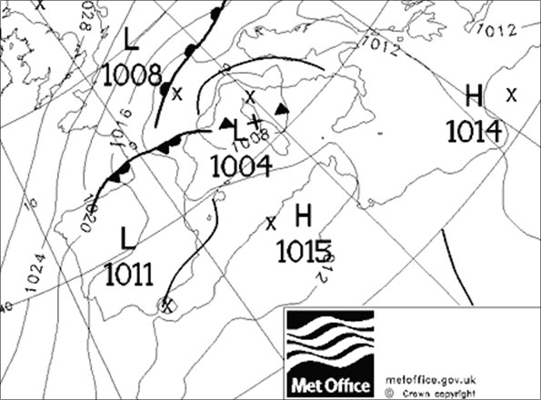
The Met Office synoptic chart (below) for midnight (GMT) Tuesday night into Wednesday illustrates the complex surface dynamics at play.
Some very heavy rain is already starting to feed north off the Mediterranean and affect parts of France, including near the likes of Nice and Monaco. You can keep an eye on this developing situation through this link to a composite loop of European rainfall radar.
 I'm Ian Fergusson, a BBC Weather Presenter based in the West Country. From benign anticyclones to raging supercell storms, my blog discusses all manner of weather-related issues. I also provide updated race weekend forecasts tied to our BBC coverage of Formula One. You can follow me on
Comments Post your comment