
Scorchio, as seen from space
Oh yes, make no mistake: I hate the term 'scorchio' and implore for it to be banned from all weather forecasts.
For ever. From now.
But now that I have your attention, it's well worth a look at the satellite images I've added below. A glorious early summer weekend, as seen in true colour from space. The imagery is courtesy of Modis Rapid Response / NASA.
The first was taken during the early afternoon today (Sunday), with unbroken skies above all of southern and central England, as high pressure sits overhead, surpressing the cloud development. Glorious stuff.
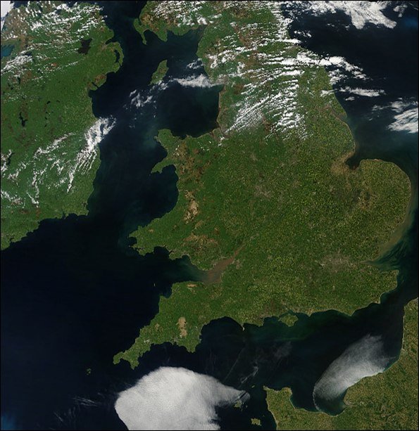 No wonder temperatures have reached 26C+, in the strong sunshine.
The second photo illustrates the slightly different story for a number of coastal areas yesterday (Saturday). Note the sea fog draped along England's North Sea coasts (and some nifty lee waves into parts of Kent, too). This all largely cleared later during the day across much of Norfolk, Essex, Suffolk and elsewhere. However, it remained stubbornly glued to some French coasts all day, formed in the slack easterly drift across cool (10-11C) sea surface temperatures. Note the airliner contrail clearly visible heading ENE out of Dartmoor.
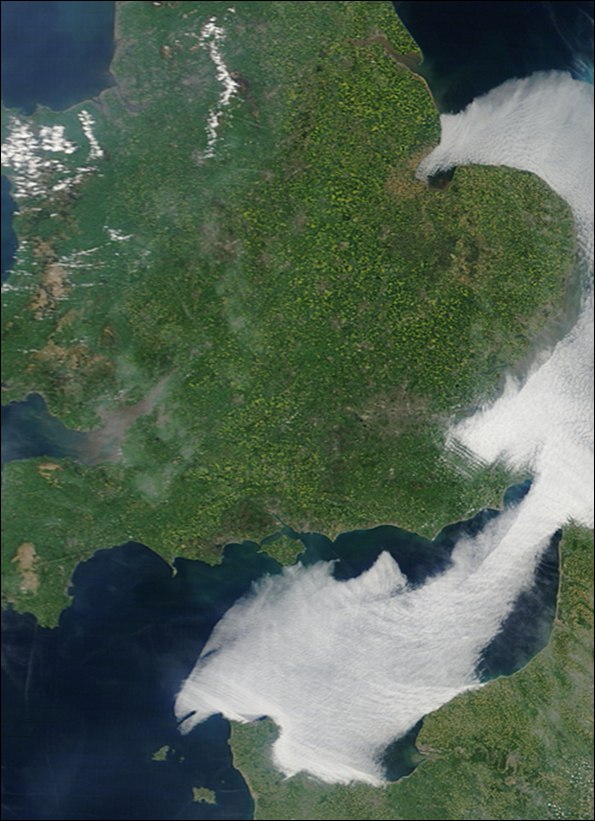 In both photos, the influence of high ground is very evident, as convective clouds build in the flow, forced upwards downwind of the Pennines, Snowdonia and some other upland areas. But without this conspicuous orographic effect to push some clouds skywards against the dominating influence of stable, subsiding atmospheric conditions, much of the nation remains cloud-free.
Monday's weather looks equally very warm (possible warmer still) for most southern districts, before we see a transition back towards seasonal average temperatures towards mid-week.
 I'm Ian Fergusson, a BBC Weather Presenter based in the West Country. From benign anticyclones to raging supercell storms, my blog discusses all manner of weather-related issues. I also provide updated race weekend forecasts tied to our BBC coverage of Formula One. You can follow me on
Comment number 1.
At 21:34 26th May 2010, Tim wrote:Great images from the past weekend Ian. I was fortunate enough to be down in Dorset and can certainly testify that for the whole time not a cloud in the sky could be seen for miles. Shame it doesn't look like this coming Bank holiday weekend will see a repeat performance of last weekend's weather.
P.S Hoping that at some point this summer we'll get chance to discuss the prospect of some decent thunderstorm activity here in the West. We are overdue some real humdingers!
Complain about this comment (Comment number 1)
Comment number 2.
At 06:37 27th May 2010, Dave Taylor wrote:This comment was removed because the moderators found it broke the house rules. Explain.
Complain about this comment (Comment number 2)