Monaco, 13-16 May 2010 (Round 6)
(This forecast will be regularly updated. This entry: Sunday 16 May, 12:50hrs BST)
Quick Links:
---------------------------------------
Nowcast / Forecast updates:
Sunday, 12.55BST: A few showers now forming close to the Italian border and across the high ground north of Monaco, being fed southwards in the prevailing flow. So, the small risk of showers remains valid, but nonethless it's odds-on to remain a dry event, as forecast.
Saturday, 09:50BST: Good morning - a brief update for you all! The risk of any showers today remains very low and so we can assume dry running should prevail throughout today; hazy sunny spells with some high cirrus cloud aloft; temperatures rising to around 20-22C by this afternoon. The dry signal for tomorrow's race remains consistently strong; still a small risk of an afternoon shower in the vicinity.
Friday, 22:30BST: Similar story to the last model output. Some minor inter-run variations as expected in this sort of set-up, but the broad theme remains as previously noted. I'm still not prepared to be bullish about the prospects for an entirely shower-free qualifying. Yes, it's certainly odds-on to remain dry, but I stress again how a shower signal in our higher resolution models remains fairly consistent, albeit a low % threat and far more likely to affect inland districts. The teams will surely remain a tad wary of this potential as they consider their strategy for the three sessions.
I'm off to Hertfordshire on Saturday morning, so can't update you weather-wise for FP3.... but hope to be doing so just ahead of qualifying, M4/M25/A1(M) traffic allowing! Hope you enjoy our coverage tomorrow, across all our platforms here on the BBC.
Friday, 12:00BST: The ensemble of 06z model runs are in broad agreement for Saturday's prospects, which reveal little significant variation from the forecast theme previously described: FP3 will be dry with sunny spells; qualifying also looks very likely to remain dry, again with pleasant sunny spells & variable cloud cover, with just a low chance of disruption from showers. Into the afternoon, these are expected to affect various districts just inland from the principality, but less so on the coastal margin. Ambient temperatures will reach 18C by 1pm local time; winds at street level will be light and mostly southerly, but with a dominant cold northerly flow up aloft. Race day also looks likely to remain dry albeit again with a generally low threat of afternoon showers.
Friday, 05:00BST: I'm just awaiting the new ensemble of model output but overnight runs have continued to offer the same broad theme for Saturday. Mostly a dry signal, but important to note that all models offer a low - but consistently present - threat of showers into Saturday afternoon. So, a dry qualifying is a more likely outcome, but by no means guaranteed. Variable cloud cover through the day, as earlier noted.
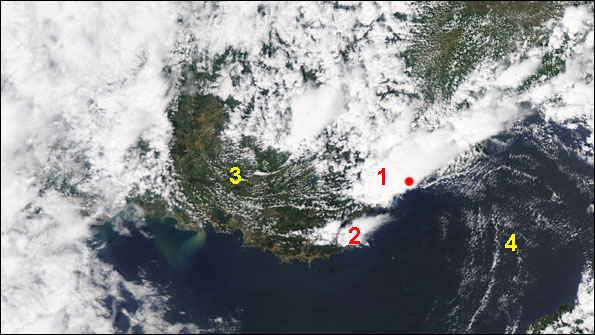
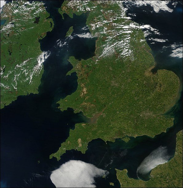
This vibrant satellite image, taken yesterday during free practice 2, shows some interesting weather aspects around southern France and Monaco (red dot) at the time. At 1, a large cumulonimbus cell was delivering thundery downpours into Nice; it's conspicuous anvil aloft swept northeastwards in the prevailing upper winds. This cell delivered some rain across Monaco towards the end of FP2. A smaller storm cell can be seen at 2. Cumulus streets are clearly visible in the brisk northwesterly flow at 3 through the Rhone valley, where the cool, dry Mistral winds have cleared much of the cloud cover. At 4, distinctive rope clouds arc across the Ligurian Sea, with low pressure sitting not far eastwards delivering a number of showers across northern Italy. (Image: Courtesy NASA/GSFC, MODIS Rapid Response).
Thurs. 20:00BST: With Saturday's free practice 3 and qualifying now just emerging into range of our higher-resolution NAE modelling, my previous forecast comments hold firm, with little significant change of emphasis. Saturday continues to look dry or mostly dry, with a continuing decline in the local rainfall signal with each successive model run. Sunny spells again expected through Saturday; dry for FP3 and very likely to remain dry during qualifying, albeit still retaining a low risk of showers. Low-level convergence and orographic influences will tend to build cloud slightly inland. This, combined with the drier N-NE flow slightly aloft, will help keep a good deal of sunnier weather along the coastal fringe of the Côte d'Azur (refer to my earlier comments on regional influences below, under 'synoptic situation & forecast evolution'). So I assume the teams, through their own meteorological advice, are also leaning towards a dry qualifying session (or at least hoping so!).
Thurs 13:46 BST: I'll be amazed if the circuit manages to dodge this storm cell... it does look highly likely to give rain there in the next 10 mins or so.
Thurs, 13:35BST: Trajectory of the storm cell we're tracking just west of circuit suggests it will pass just north of Monaco shortly....heavy downpours being recorded from it on radar.
Thurs, 13:05BST: Our high-resolution lightning detection system via the Met Office is recording a lot of lightning flashes now from a storm cell just west of Monaco.... if it (or other similarly lively cells) crosses the circuit, which is quite possible, it will give a real downpour.
Thurs, 12:20BST: So far, so good with today's forecast. Showers now readily forming just inland across neighbouring coastal localities with precipitation from these cells fed ENE in the prevailing flow. These are being formed with influences of local orography. Certainly not impossible to see some affecting the circuit for free practice 2; albeit most will preferentially form slightly further inland above and upstream of the higher ground. Local rainfall radar available at https://www.meteoliguria.it/dati_osservati/areali/radar.html?type=rpa
---------------------------------------
Current Forecast Headlines:
Thurs: Sunny spells; Max 18C. A few showers possible PM.
Sat: Variable cloud cover & sunny spells; Max 21C. A few showers possible PM.
Sun: Sunny spells; Max 21C. Light winds. Dry race expected.
--------------------------------------
It's back-to-back races this week and hot on the heels of departing Barcelona, we now turn our attention to Formula One's iconic, inimitable race at Monaco.
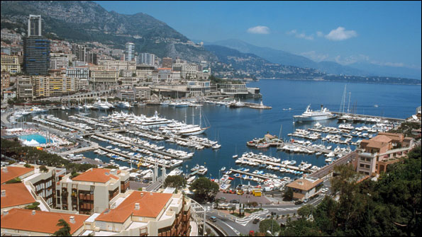
Monaco's skyline is not guaranteed the dry, sunny conditions prevailing in this view, as the F1 event gets underway on Thursday against a backdrop of unsettled weather across the region.
I absolutely love this event and I'm sure many (most?) of you share my view. As so many other historic circuits become rather emasculated, there's something very special about Monaco: the unashamed opulence and vibrancy; those tiny margins of error between utterly unforgiving barriers; the sheer brilliance of those who can throw an F1 car around this extraordinary place - lap after lap, in metronomic fashion - with seeming aplomb.
And then there's the weather.
Chuck even a sprinkling of rain across the asphalt at La Rascasse, Casino Square or Loews Hairpin, and you're sure to stamp 'drama' onto every lap around this place. The very best in this sport have triumphed here in the wet; most - at some point - have also crashed in it, too. Inarguably, few races on the calendar prove so compelling from start to finish.
Once again, we're looking at another weather story worth following right to the chequered flag: because with all our forecast models indicating further unsettled weather across much of the western Mediterranean and mainland Europe between now and race day, I have little doubt we're into another journey of a changeable local forecast emphasis.
Synoptic situation & forecast evolution:
The one certainty, weather-wise, is that the Azores high will dominate out in the North Atlantic and low pressure likewise across central Europe and the Northern Mediterranean.
A substantial upper ridge sitting north-south in the Atlantic will once again provide an effective blocked pattern, while an upper trough, dangling all the way out of Iceland down to southern Europe, will dictate the weather across much of continental Europe and continue to offer unseasonably cool conditions for many.
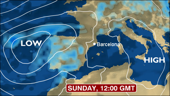
Rather continuing a theme we saw emerging ahead of the Spanish GP, a surface low pressure system has established this week in the western Mediterranean, from where it has evolved into a very dominant feature, migrating northwards into eastern-central Europe. With attendant fronts and troughs feeding-down in the northerly flow, bouts of wet (and in some places, very wet and thundery) weather will spread across many parts of southern France, northern Italy, Switzerland and environs through to the weekend, including - periodically, at least - across Monaco itself. My colleague Sarah Holt's hastily-snapped photo taken en-route to Monaco says it all!
During Thursday, the dominating upper trough sits all the way from the Arctic down across the British Isles, western Europe to the Western Mediterranean. On Saturday, an upper vortex forms above the northern Adriatic, coupled to a quite vigorous surface low that will drift across the northern Balkans towards the Black Sea into Sunday. It'll provide further emphasis for unsettled weather across southern France and northern Italy at times into the weekend. There's a strong inter-model signal for pressure rising slowly from the west into Sunday, which should steadily supress the risk of showers into the afternoon to potentially offer a dry race throughout. However, with a surface low never far away to the east, at this juncture it's impossible to reliably call the the race prospects for this event as wholly dry.
One regional feature that will probably become evident into the weekend, with the surface low evolving above northern Italy, is the northwesterly Mistral and northerly Tramontane winds blowing down across Provence and also into the Côte d'Azur. Cold air is fed down off the Alps towards Monaco, but there's some important localised factors at work that will very much dictate how the weather materialises across the principality on Thursday and Saturday especially.
As the flow spills down off the high ground encircled behind Monaco, it tends to undergo some degree of Foehn effect (adiabatic) warming, helping clear the skies coastally. At the same time, and probably more importantly for this race event, a southerly low-level breeze off the Mediterranean is forced up orographically over the same high ground, condensing-out to offer - with convergence assistance too - towering cumulus clouds and an attendant shower risk a short distance inland. The coastal fringe and circuit, meanwhile, can stay brighter and dry, whilst the peaks north of Monaco remain draped in cloud. It's going to be interesting watching satellite and radar to see if this combination of localised effects helps spare the track sessions from much of the showery wet weather... or not!
Session Forecasts
 Thursday's practice sessions (remember: there's no track action on Friday here!) could prove the first test in terms of how the local weather behaves, or not, for this year's event. Forecast modelling for the day has shown pretty good continuity and it's now well into range of the Met Office's higher-resolution NAE model. With a trough sitting effectively SW-NE across southern France (see latest Met Office synoptic chart, below), there's a potential for some showers at times. A sunny morning expected; free practice 1 will almost certainly stay dry. There's a growing, but still fairly low risk of showers affecting free practice 2; ambient temperature will reach 17-18C. Quite a breezy day at times - especially down at the marina and seafront - with winds from the SW/SSW. Any rainfall accumulation from start of FP1 to end of FP2 unlikely to exceed 1-3mm.
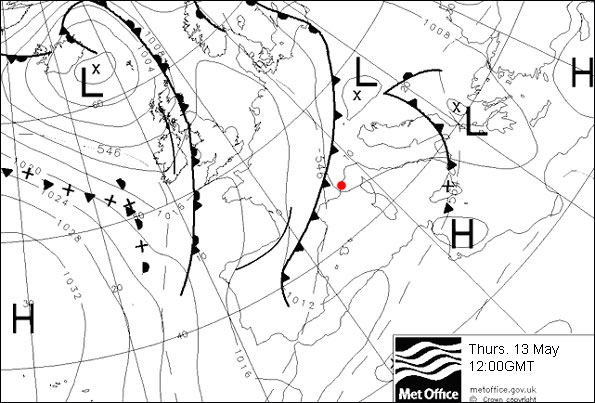
The UK Met Office's latest synoptic chart for 12:00 GMT on Thursday shows a trough draped through northern Spain and across towards northern Italy, likely to deliver showers into Monaco (red dot) at times (Image: Courtesy UK Met Office)
Saturday's current forecast expectations, with low pressure centred out east across the Adriatic (see chart, below), are still impossible to localise with anything more than moderate confidence. Modelling continues to suggest a dry session for free practice 3; a fair chance of a dry qualifying too, but a low chance (increasingly so, in most model runs) of some showers into the afternoon.
Forecast continuity has reasonably consistent for Saturday afternoon, indicative of light to moderate showers developing in districts from Nice eastwards to Liguria. Crucially however, the modelled signal for rain is significantly higher further inland rather than coastally and also eastwards of Monaco. By Friday we'll see how the higher-resolution models support these prospects. Winds will be lighter than Thursday; predominantly from the SW; with ambient temperature 16-17C. The teams will be keenly watching Saturday's forecast developments, not least given the concerns about qualifying for this event, already expressed by some team principals and drivers. Clearly, rain is by no means a certainty at this juncture, but to quote our Met Office Duty Forecaster at BBC Weather Centre, in a conversation with me on Tuesday:
"It would be worthy of a major pay rise if any F1 team employee guarantees, at this stage, a dry day throughout all of Saturday... and duly delivers the goods".
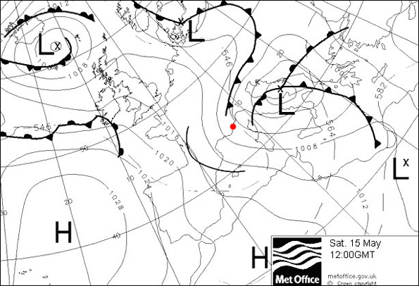 The UK Met Office's synoptic chart for 12:00 GMT on Saturday calls for low pressure easing eastwards into the Balkans and a chance of showers forming through parts of southern France and northern Italy. It'll be a radar-watching story at Monaco that afternoon. (Image: Courtesy UK Met Office)
Sunday's race prospects, with all models agreeing on pressure building from the west, are broadly indicating improved conditions. Bar a generally small chance of showers still evident in some modelling, all forecasts lean heavily towards a dry event. Hazy bright or sunny spells across the principality; an ambient temperature around 17-18C and a mostly light southerly breeze.


 I'm Ian Fergusson, a BBC Weather Presenter based in the West Country. From benign anticyclones to raging supercell storms, my blog discusses all manner of weather-related issues. I also provide updated race weekend forecasts tied to our BBC coverage of Formula One. You can follow me on