
Stormy weather for late Friday? (with updates)
UPDATE, THURSDAY 12 NOV., 14.00hrs:
So, the expected heavy rain is now upon us and it's proving a frantic day here at the weatherdesk in BBC Bristol.
The rest of this afternoon and the early evening will see some treacherous conditions on the roads across the West, with up to 15mm of rain falling and some strong winds for a while.
I'm especially watching the developments within this front, visible in the rainfall radar image below. See those bright pink and white areas into Somerset, starting to form discrete lines? It's the incipient phase of a phenomenon called line convection and where these occur, they're likely to provide some very squally conditions, perhaps even dropping a small tornado somewhere.
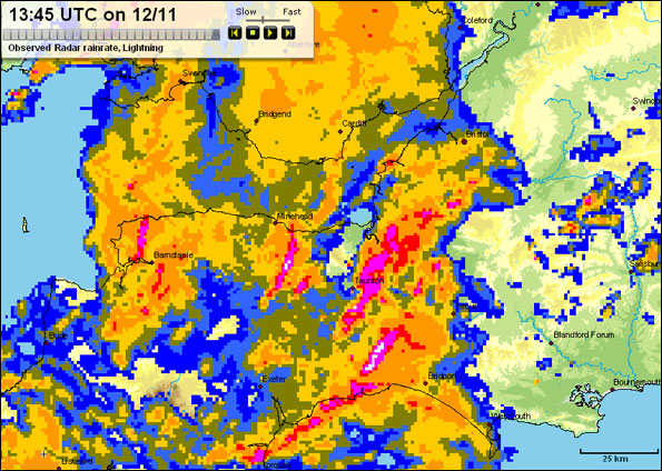
Met Office rainfall radar image for the Westcountry, 13:45hrs, Thursday 12 November 2009
UPDATE, WEDNESDAY 11 NOV., 16.20hrs:
I just came off the 'phone after another briefing from my Met Office colleagues at BBC Weather Centre (the inimitable Rob McElwee in this case) - and the evolving story remains broadly the same, albeit with some key points worth highlighting:
Firstly, whilst we've been emphasising Friday's inclement weather, let me stress that tomorrow evening (Thursday) will also see some very wet and windy weather spreading eastwards, giving worsening conditions for many districts by the evening rush-hour;
Secondly - after only a brief dry interlude later on Thursday night - there's a chance that heavy rain could be across the Westcountry even by dawn on Friday - ahead of further very wet and windy weather continuing through the rest of the day.
And Saturday is now included in the extended Met Office weather advisory I mentioned in yesterday's blog entry (above).
ORIGINAL ENTRY, 10.11.09, 17.16HRS
I'm penning this short entry to highlight our growing expectation for the working week to end with some potentially - and I stress potentially - wild weather.
 Yesterday, the Met Office issued an early advisory for this likelihood, with a focus for the worst weather developing during Friday evening, overnight into Saturday.
We're still some way off seeing the forecast detail firming-up, but the various forecast models we use (and you can see a selection here) paint a broadly similar story: some very wet and very windy weather brewing in the Atlantic by Friday afternoon, with Saturday starting in similar fashion.
More on this as the forecast develops....
 I'm Ian Fergusson, a BBC Weather Presenter based in the West Country. From benign anticyclones to raging supercell storms, my blog discusses all manner of weather-related issues. I also provide updated race weekend forecasts tied to our BBC coverage of Formula One. You can follow me on
Comment number 1.
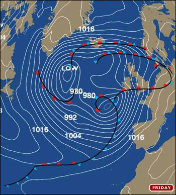
At 16:40 13th Nov 2009, Wendy RedredRobin wrote:Appreciate the inclusion of the isobar map on your blog, the strength of the wind is of great concern in these winter storms, would it be possible to zoom in over the Points West region as you have done with the rainfall radar?
Complain about this comment (Comment number 1)
Comment number 2.
At 14:21 14th Nov 2009, Ian Fergusson BBC Weather wrote:Hi Wendy - next time I put one on the blog, I'll certainly give that a try. Thanks for the suggestion! Best, Ian
Complain about this comment (Comment number 2)