
Rain will Fall from Grace...
I'd better use my day off to get out and mow the lawn, pronto.
I find trying to cut grass that's damp typically tedious, impossible, or both
. And it looks like some fairly heavy rain will fall here in the West Country at times on Tuesday and into Wednesday.It's an interesting weather situation heading our way, because the inclement conditions will arrive courtesy of Tropical Storm Grace, currently spinning herself north-eastwards towards the British Isles
, far off the tip of northwest Spain. She's the seventh tropical storm of the (thus-far rather quiet) 2009 hurricane season to be given a name.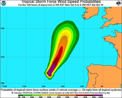 Tropical Storm Grace is expected to move steadily northeast, as shown in this forecast graphic from the Miami-based NOAA National Hurricane Center
Grace is expected to carry quite a punch and sustain winds up to 70mph for a while, until she moves up to around 50 degrees North and weakens. While the storm will remain way offshore over the ocean, it'll certainly present a potential hazard out there for mariners.
But before reaching us, she'll become an ex-Tropical Storm
, having steadily lost potency and wind strength by travelling across the cooler waters of the eastern North Atlantic. Nonetheless, Grace will still keep a core of warm, moisture-laden tropical air and may even deepen a tad, pressure-wise, as she rolls-up into the Southwest Approaches of the British Isles.Ex-Tropical (or post-tropical) storms can't be underestimated - they can still bring some pretty nasty weather into higher latitudes, far from where they were born over the warm waters off West Africa.
For us, Grace brings a real chance of some fairly heavy rain but the forecast difficulty for us (and lucky me, just as I return to work) is trying to pin-down exactly which parts of our region will see the wettest conditions. OK, so nothing exceptional expected, but some heavy-ish rain for sure and I suspect this will struggle to soak quickly into the ground, after the prolonged, largely dry spell of late.
So one way or another, certainly enough wet weather on it's way to completely curtail my lawn-cutting efforts before I'm back at work, unless I stop writing, get outside and get a move on...
UPDATE, 20:30hrs, Monday 05 October:
I just read the very latest detailed Met Office briefing we've received on tomorrow's weather prospects. It's possible the West Country will escape prolonged heavy rain, but there's considerable uncertainty about the precise track and rainfall potency of Grace. South Wales looks likely to get a soaking, however.
Perhaps we will see only light, sporadic rain here in Bristol, but with heavier pulses passing-through at times in the morning. Either way - as I noted above - nothing exceptional. But Grace still remains a local forecasting headache... welcome to my world!
The lawn proved too damp to mow anyway.
Or at least, that's my excuse.
UPDATE 14.45hrs, Tuesday 06 October:
I've just been looking on our Met Office weather briefing system at the very latest spectacular satellite photos of ex-Tropical Storm Grace, currently located just south of Ireland. The image (below) shows Grace's impressive and distinctive spiral vortex, as she continues to retain some structural identity and delivers a noticeably mild, humid and wet day here across the West.
![Ex-Tropical Storm Grace, south of Ireland, on Tuesday 6 October 2009 (Copyright [2009] EUMETSAT](https://bbctodays.pages.dev/blogs/weather/ianfergusson/grace_vissat.jpg) Ex-Tropical Storm Grace, easily spotted from her distinctive spiral vortex, photographed here by satellite during the afternoon of Tuesday 6 October 2009 (Photo: Reproduced via Met Office from EUMETSAT original)
Ex-Tropical Storm Grace, easily spotted from her distinctive spiral vortex, photographed here by satellite during the afternoon of Tuesday 6 October 2009 (Photo: Reproduced via Met Office from EUMETSAT original)
UPDATE, 20:25hrs Tuesday 06 October:
We're expecting spells of heavy rain across some districts of the West tonight and again later tomorrow (Wed) afternoon and evening from this system. Could get pretty interesting for some districts of southern/central England and Wales, in terms of rainfall totals. If you are into severe / newsworthy / noteworthy weather, you might want to check-out Met-Monkey, where you'll find a forum (link on top navigation bar of their site) of like-minded and friendly folk, with some excellent meteorological brains behind it all. A great free site.
 I'm Ian Fergusson, a BBC Weather Presenter based in the West Country. From benign anticyclones to raging supercell storms, my blog discusses all manner of weather-related issues. I also provide updated race weekend forecasts tied to our BBC coverage of Formula One. You can follow me on
Comment number 1.
At 20:14 6th Oct 2009, Cliff-T wrote:Tomorrow should be interesting across Southern counties, what with Grace feeding some heat into that secondary LOW to her South West.
Grass was mowed here on Monday, but it's looking quite lush after the past couple of days worth of rain. I shall look forward to tomorrow's rainfall, certainly one to watch for. :-)
Complain about this comment (Comment number 1)
Comment number 2.
At 20:19 6th Oct 2009, BristolWeatherLady wrote:Hello Ian, thank-you for this interesting blog! I only found it through a posting sent on a UK weather discussion forum, please don't keep it so secret! Great that the BBC has started something like this. I have cloud photos to send to Points West and will email them as per your instructions. Will Tropical Storm Grace give any lightning tonight for us? Or just rain? Some people on some forums think it will get really bad tomorrow with floods in some places? What do you think?
Thanks for any reply,
Julie
Complain about this comment (Comment number 2)