
Enjoy it while it lasts...
Time for a brief update looking ahead towards the weekend, when - albeit mild conditions will still prevail - some very wet weather could become a feature, at least for a while.
Our balmy weather continues through to the end of this working week, as discussed in my last blog. More cloud around for many across the West tomorrow (Wednesday), but 17-18C still widely on the cards irrespective of any grey skies. A better chance of more widespread brighter conditions returning on Thursday and cloudier again by Friday... and by then, we'll have grown accustomed to daytime highs around 18C and overnight lows around 13-14C (that's about twice the average for this time of the year!).
Dark, rain-bearing skies are expected to return across the West mid-weekend... but the forecast detail remains uncertain, at least for now.
So, my attention now focuses further ahead, into the weekend. Never straightforward, my job (refer to previous comments here!) and sure enough, it's currently a tricky forecast - with various possible outcomes - keeping my grey matter working at overdrive on these early morning shifts.
Our present expectation is for dry, bright and increasingly breezy weather during the bulk of Saturday to be replaced by wet - and potentially very wet - conditions developing overnight into Sunday morning.
The regional forecast precision remains elusive at this stage, but with the focus for heaviest rain somewhere across southern / southern-central England. Watch this space and I'll keep you updated on the evolving Met Office forecast...
As for next week? Well, by midweek we expect a return to temperatures somewhere around the seasonal average. Unsettled weather, in the continuing west/southwesterly flow off the Atlantic, will dominate proceedings - possibly accompanied by some very windy conditions at times.
UPDATE, 19.45hrs, WED 28 OCTOBER:
We continue to watch the forecast evolution of deep cyclogenesis for Saturday night, with the story broadly painting the same picture: turning very wet and windy.
But exactly how wet, and how windy?
 Our difficulty remains establishing the precise track of this depression. Consequently, it's regional impact across the British Isles - in terms of any severe weather potential - remains very speculative, for now. But over the next 48 hours, successive runs of the Met Office's NAE (North Atlantic Evolution) model, alongside those produced by other nations such as those you can see online here, will help flesh-out some likely detail as we get nearer to the weekend.
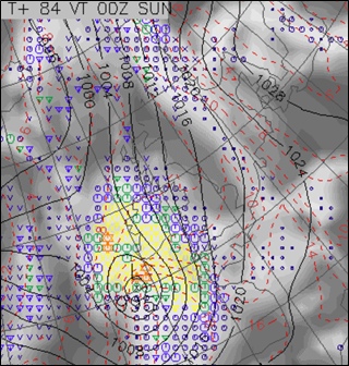
I've just been reading through an updated briefing received from the Met Office Operations Centre in Exeter. Their latest frame valid for Saturday night (see right) highlights the key features we can expect: those tightly-packed isobars signifying the windy weather approaching from the southwest; the associated bright yellow colours denoting a swathe of heavy rain. We rely heavily on this sort of broadscale and subsequent higher detail (i.e., typically near-term models run at a resolution of 4km) forecast output from our Met Office colleagues, when determining your local forecasts.
Will the Trick or Treating types get a drenching over the weekend? It's looking likely (and I dare say some of you may have mixed views on that prospect!). Watch this space...
 I'm Ian Fergusson, a BBC Weather Presenter based in the West Country. From benign anticyclones to raging supercell storms, my blog discusses all manner of weather-related issues. I also provide updated race weekend forecasts tied to our BBC coverage of Formula One. You can follow me on
Comment number 1.
At 13:32 28th Oct 2009, Uncle_Deedee wrote:Ian, just a point about the presentation of your blog.
Not sure what the technical terminology is or whether it can be easily altered, but the bits that are highlighted and underlined that...(is it called)'hyperlink' to other pages. They are very difficult to distinguish from the rest of the writing because, well on my laptop anyway, they appear a very similar colour. Are they set for dark blue? Can you not set them for a lighter blue or another colour so as to easily contrast with the general black typeface. People may be missing out a lot because of this...just a thought.
Complain about this comment (Comment number 1)
Comment number 2.
At 20:25 28th Oct 2009, Ian Fergusson BBC Weather wrote:Hi Uncle_Deedee - many thanks for the feedback. I'm seeking technical advice to resolve your query; I agree that on some screens / browsers, the default hyperlink text colour is not very clear and too dark a shade of blue. I'm sure we can resolve this for you... please bear with me while we sort it out! Best, Ian
Complain about this comment (Comment number 2)