
A cloud question from Gloucestershire...
Bob Faraway from Eastington - not far off the M5 near Stroud, Gloucestershire - has e-mailed me a photograph of clouds he watched passing above his home on Monday morning.
"Please can you advise what might cause these cloud formations," Bob asks, "as they look unusual to me?"
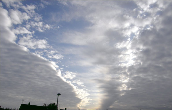 Well, they're not actually unusual per se. Bob has photographed the higher levels of cloud building-up well ahead of the frontal system that ultimately brought yesterday's rain.
The cloud itself is predominantly Altocumulus stratiformis, forming at mid-levels in the atmosphere and signalling the eventual arrival of the occluded front discussed in Tuesday's blog. But this feature was still a long way west of Eastington when Bob snapped the shot.
 The elongate clear slot visible in his skyscape is likely to signify where drier air is descending; thereby disrupting the otherwise extensive cloud cover. All manner of changes to atmospheric pressure, temperature, humidity and winds aloft can create sudden gaps in large areas of cloud. Quite often, they're created by the wave-like disruption of airflow passing across hills, mountains and other terrain (a type of standing atmospheric wave known as lee waves).
With each increasing hour after Bob took his photo, the cloud cover above Eastington would have steadily increased, lowered and thickened.
Through Friday into Saturday, we will see a similar story emerging in the skies above the West Country, as another Atlantic depression sweeps eastwards towards the British Isles, heralding further wet and rather windy weather - especially on Saturday itself.
 I'm Ian Fergusson, a BBC Weather Presenter based in the West Country. From benign anticyclones to raging supercell storms, my blog discusses all manner of weather-related issues. I also provide updated race weekend forecasts tied to our BBC coverage of Formula One. You can follow me on
Comments Post your comment