Parts of UK at risk of renewed flooding

Paul Hudson
UPDATE at 6.30pm
Lastest information from American GFS model shifts emphasis for heavy rain towards the earlier ECMWF solution detailed below, i.e with much of Yorkshire and Lincolnshire at risk of some of the highest rainfall totals.
ENDS
Amber alerts are in force for parts of the UK tomorrow, with heavy prolonged rain likely to lead to renewed flooding in places.
This is on top of possible localised flooding from scattered thunderstorms today, and a risk of flooding on saturday across parts of Northern Britain.
Computer models have in the last few days consistently developed an area of low pressure over the near continent tonight, bringing the centre across East Anglia and the Midlands tomorrow.
This feature will be very active, driven by high humidity air, leading to prolonged heavy, thundery rain.
The precise northern and southern boundary of this area of rain is open to some doubt at the moment.
The chart below, from the UK Met Office, gives an indication of the highest risk area (yellow) of the heaviest rain (50mm or more in total on Friday), with East Anglia, the Midlands and Wales in the firing line.
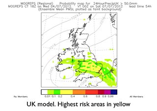
The area fringes into parts of Yorkshire and Lincolnshire too. This is considered to be the most likely outcome at the moment.
But the European Centre for Medium Range Forecasting (ECMWF) model, shown below, has the risk of disruptive rainfall further north (Red), with parts of Yorkshire and the Humber at highest risk.
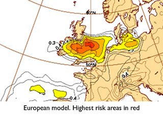
The European model arguably offers the most consistent and reliable guidance for weather forecasters, and gives an insight into the on-going uncertainty regarding the positioning of tomorrow's heavy rain.
Whichever is correct, with much of the land now saturated, another month's worth of rain in less than 24 hours tomorrow will inevitably lead to renewed flooding across parts of the UK.
Follow me on twitter @Hudsonweather
