
February: Westerlies come roaring back
January 2011 turned out to be drier and colder than average. The provisional Central England Temperature (CET) mean for the month was 3.7C, compared with the average of 4.2C.
It was a month again dominated by high pressure, with north and east winds more frequent than normal. Rainfall was therefore below average.
Most of January's rain fell between the 8th and 16th, as Southwesterly winds brought rain bearing clouds in from the Atlantic.
Leeming recorded 30.2mm of rain, compared with the average 54.9mm. This follows December which was exceptionally dry, with 17.6mm compared with the average 58.5mm.
Bradford recorded 54mm of rain, compared with their average of 86mm.
Despite the dry winter so far, Yorkshire's reservoirs are looking quite healthy, standing at 92% of capacity. By the end of February, they should be full.
This is because February looks set to see a very different kind of weather compared with what we have experienced in winter so far.
The jet stream, having spent long periods to the south of the UK is repositioning itself across our latitudes, bringing with it a much more traditional type of winter weather.
The first half of February will be dominated by vigorous areas of low pressure bringing strong winds and rain from the Atlantic, with temperatures mostly near or above normal.
Although there may be brief incursions of colder air, with a risk of transient spells of snow over the hills over Northern Britain, a return to the conditions we experienced during the first half of winter seems most unlikely.
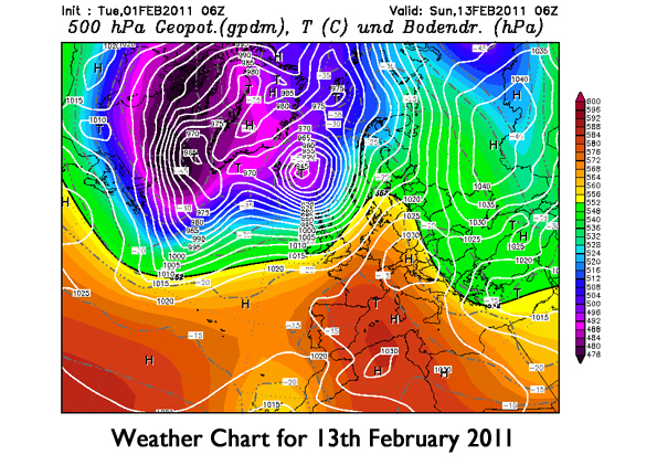
The chart below is indicative of what we can expect - high pressure over Southern Europe, with areas of low pressure tracking to the Northwest of the UK, bringing their associated weather fronts across us from time to time from the west.
 Hello, I’m Paul Hudson, weather presenter and climate correspondent for BBC Look North in Yorkshire and Lincolnshire. I've been interested in the weather and climate for as long as I can remember, and worked as a forecaster with the Met Office for more than ten years locally and at the international unit before joining the BBC in October 2007. Here I divide my time between forecasting and reporting on stories about climate change and its implications for people's everyday lives.
Comments
Sign in or register to comment.