
Will February see a return of the big freeze?
A lot of you have sent me e-mails asking me the same question: Will we see a return to the cold and snowy conditions that affected us a few weeks ago?
Over the next 24 hours an Arctic northerly will develop, as predicted by the various worldwide weather models in my update on Sunday, with a cold weekend in prospect.
Longer term as you might expect forecasting is a much more difficult job to get right, but there are signs of what might lie in store.
We have already discussed stratospheric warming in previous blogs. The idea is that extra warmth in the stratosphere can cause a blocking type of weather to develop in the troposphere, the area of the atmosphere where weather patterns affect us. Well, stratospheric warming commenced last week. This suggests that a blocking pattern of weather is possible into February.
Other indicators we look at are pressure patterns across the Arctic and the North Atlantic. Both the North Atlantic oscillation (NAO) and the Arctic oscillation (AO) have gone into their negative phase again, having temporarily turned positive around the middle of the month - and are forecast to stay that way into early February.
Without getting too technical, both these pressure pattern changes suggest that the jet stream could be pushed to the south of us once more, leaving us susceptible to colder air, with high pressure likely to build to the north of us - dragging cold air across us from the east.
None of these 3 features are a guarantee of a prolonged cold spell of weather - but the balance of probabilities are now tilting towards this being the most likely scenario.
The final piece of the jigsaw is the ensembles, again mentioned in a previous blog. Remember that the computer runs a number of times, very slightly altering the initial atmospheric conditions to see how that will change future projections. And the various computer models from across the world are telling us more or less the same story. That there is every chance of a blocked pattern of weather becoming established towards the end of next week, which could lead to bitter easterly winds and a risk of snow.
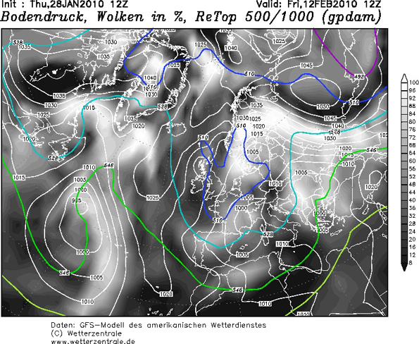
Below is an example of what the American operational model expects to happen from the latest midday run of the computer. It gives an idea of the type of pattern that may occur. Of interest are the coloured lines, called thickness lines, labelled 510 in deep blue. This depth of cold air has become quite rare across the UK in recent years.
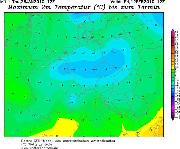
This shows the expected temperatures at midday: Exceptionally cold across the whole of Europe.
At this stage, I have to sound a note of caution: None of this is set in stone and meteorologically we are a long way away from it becoming reality. But if this pattern does become established, then it could overall turn out to be the coldest winter since 1978/79 - a big departure from the run of very mild winters that we have grown accustomed to.
I will update this blog next week
 Hello, I’m Paul Hudson, weather presenter and climate correspondent for BBC Look North in Yorkshire and Lincolnshire. I've been interested in the weather and climate for as long as I can remember, and worked as a forecaster with the Met Office for more than ten years locally and at the international unit before joining the BBC in October 2007. Here I divide my time between forecasting and reporting on stories about climate change and its implications for people's everyday lives.
Comments
Sign in or register to comment.