
A severe start to 2010
It's been the coldest December averaged across the UK since 1996. But here in Yorkshire it's been even colder than that at some sites. Leeming, in North Yorkshire, has had its coldest December since 1981 which is remarkable considering that during the first 10 days of the month we were still stuck in the mild and wet weather left over from November.
This week looks potentially disruptive with a high risk of some heavy snowfall. A weather front tonight will bring an awkward mix of freezing rain, sleet and snow from the north just in time for Tuesday mornings commute. Then the wind will swing round to the North or Northeast, and with deep cold air coming over a relatively mild North sea (although sea temperatures have fallen 3-4 degrees in the last 3 weeks) heavy snow showers are likely to form, and merge into longer spells of snow at times especially, but not exclusively, in eastern areas, with no let up expected in this type of weather even as we head into the weekend. Severe frosts are also expected at night, with daytime temperatures struggling to get above freezing point. Some places by Friday may have over a foot of snow.
And there is absolutely no sign of any change soon. More than 80% of weather models have a cold east or northerly type of weather lasting for the next 10-15 days. At the same time our usual wet and windy weather is way to the south, with the Jet stream lying somewhere through the Mediterranean. Hardly surprising that parts of southern Spain has had flooding not seen since the 1940's.
So it's looking increasingly like a winter the like of which we haven't seen for decades.
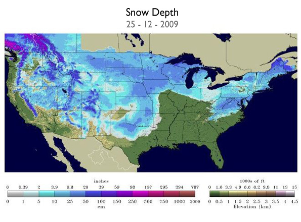
And this weather pattern is not unique to the UK and Europe. The NOAA satellite map below shows the extent of snow in the USA on Christmas day when a remarkable 63% of the country was covered in snow.
 Hello, I’m Paul Hudson, weather presenter and climate correspondent for BBC Look North in Yorkshire and Lincolnshire. I've been interested in the weather and climate for as long as I can remember, and worked as a forecaster with the Met Office for more than ten years locally and at the international unit before joining the BBC in October 2007. Here I divide my time between forecasting and reporting on stories about climate change and its implications for people's everyday lives.
Comments
Sign in or register to comment.