Find out the basics about weather systems
- looking for a quick introduction to weather in the UK?
- want to refresh what you've learned before?
- read on for our quick guide to all you need to know about weather systems for National 5 Geography.
- use the links at the end of each section if you want to find out more details.
How do latitude, relief, aspect and distance from sea affect weather?
Latitude - places closer to the Equator are usually warmer, and places nearer to the North Pole and South Pole are colder.
- sun passes through more atmosphere at high latitudes, so loses more energy before it reaches the ground
- sun is spread over a wider area at high latitudes, so its energy is spread more thinly over a wider area
- locations at higher latitudes have more seasonal changes in weather
Relief - places located on flat low-lying land are warmer and places higher up, ie mountains, are colder and wetter.
- air is thinner at higher altitude so it can hold less moisture
- in the UK, prevailing winds from the southwest and west bring relief rainfall to higher western areas, and drier weather to lower eastern areas
Aspect - in the northern hemisphere, places which are south-facing are warmer and places which are north-facing are colder.
- south-facing slopes receive more sunlight
- north-facing slopes are more exposed to cold northerly winds
Distance from the sea - places nearer to the sea are mild and wet, and places further from the sea are drier, but temperatures are more extreme.
- water takes longer to heat up, keeping areas near the sea cooler in summer
- water takes longer to cool down, keeping areas near the sea milder in winter
Find out more in our National 5 article all about how latitude, relief, altitude and distance from the sea affect weather in the UK.
How do air masses affect UK weather?
Watch this video to find out which air masses affect the UK, where they come from, and the weather they bring.
Find out more about how air masses affect UK weather
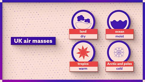
Air masses are large volumes of air that bring different weather conditions.
Tropical air masses from the tropics bring warmer weather
Arctic and polar air masses from the Arctic and poles bring colder weather
Continental air masses from over land bring drier weather
Maritime air masses from over the ocean bring wetter weather
Five main air masses affect the UK
- Tropical Maritime (mT) - brings warm, wet weather from the Atlantic Ocean
- Tropical Continental (cT) - brings warm, dry weather from North Africa
- Polar Maritime (mP) - brings cold, wet weather from the North Atlantic
- Polar Continental (cP) - brings cold, dry weather from Siberia
- Arctic Maritime (mA) - brings very cold (sometimes wet) weather from the Arctic Ocean
Find out more in our National 5 article all about how air masses affect UK weather.
What weather do depressions and anticyclones bring?
In this video, revise the characteristics of weather associated with depressions and anticyclones.
Depressions are areas of low pressure that always bring rain. They move from west to east in the Northern Hemisphere and represent the boundary between two air masses. Isobars are lines on a synoptic chart that join areas with the same air pressure. The centre of a depression shows the lowest atmospheric pressure. The closer together the isobars, the stronger the wind.
When warm air meets cooler air, a warm front forms. As the warm front moves eastward, the warm air rises above the cooler air, forming clouds and bringing steady, continuous rain. As the warm front passes, it is followed by a mass of air called the warm sector. Temperatures rise due to warmer air, and skies will clear briefly.
The cold front follows, and as cold air meets warm air, the warm air is pushed upwards rapidly. This leads to the formation of dark cumulonimbus clouds, a drop in temperature and heavy rainfall. An occluded front occurs when the cold front catches up with the warm front, resulting in prolonged heavy rainfall.
In a depression, isobars are close together because of sudden changes in air pressure. Strong winds blow anti-clockwise around the depression, meaning that on this chart, Fort William experiences westerly winds.
Areas of high pressure are called anticyclones and bring extended periods of settled weather. Synoptic charts show pressure decreasing outward from the centre above 1008 millibars. During summer, anticyclones result in clear skies and high temperatures, while in winter they bring lower temperatures, often leading to frost and fog.
Clouds rarely form in anticyclones because, as cooler air sinks, it warms up and can hold more moisture. The weather remains dry in Leon as there are no weather fronts and few clouds. Winds blow clockwise around areas of high pressure, meaning a westerly breeze, shown by widely spaced isobars.
Depressions are areas of low pressure.
They move from west to east.
Depressions are characterised by fronts:
- warm front - warm air rises over cold air bringing steady, continuous rain
- cold front - cold air forces warm air up bringing heavy rain showers
- sometimes an occluded front forms - cold front catches up with warm front bringing sudden downpours
Anticyclones are areas of high pressure
- skies are clear and the weather is usually dry
- winds are gentle
- summer - hot during the day but cold at night
- winter - very cold
| depression | anticyclone | |
|---|---|---|
| pressure | low | high |
| isobars | close together | far apart |
| wind | strong | gentle |
| wind direction | anticlockwise | clockwise |
| precipitation | wet | dry |
| duration | short - 2-3 days | longer - can last more than one week |
Find out more in our National 5 article all about depressions and anticyclones.
How do you read synoptic charts and weather circles?
The main weather element of a synoptic chart is air pressure:
- isobars are black lines joining areas with the same air pressure, usually 4 mb apart
- air pressure is shown in numbers in millibars and/or in words showing high (H) or low (L) pressure
Fronts show the boundaries where air masses meet
- warm front - red line with semicircles
- cold front - blue line with triangles
- occluded front - purple line with triangles and semicircles
Fronts move in an anticlockwise direction.
Weather circles show current weather at a particular location
- temperature in °C
- cloud cover in This is the measurement for cloud cover. Each okta makes up one eight of the sky and helps us to understand how much of the sky is covered in cloud.
- wind direction - tail points to where wind is blowing from
- wind speed in knots
- precipitation
Find out more in our National 5 article all about reading synoptic charts and weather circles
More on Weather systems
Find out more by working through a topic
- count3 of 6