

�In pictures:�Famous sites' flood risks
Wet Westminster
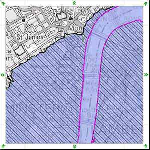
The Environment Agency's flood map reveals areas (shaded hatched blue) that would be liable to flood if it weren't for defences.
Entering the postcode for the Houses of Parliament, SW1A 0AA, reveals that much of Westminster would be at risk if it weren't for the extensive Thames defences (in pink).
All images copyright The Environment Agency
