The missile uses hi-tech mapping software to find its way
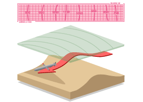
At the heart of the cruise missile is TERCOM - Terrain Contour Matching - software that allows the weapon to "read" the ground it flies over. The missile carries a three dimensional map of its route, produced by the US National Imagery and Mapping Authority.
TERCOM compares a picture of the ground to one in its memory and adjusts its course accordingly. Theoretically, this allows it to maintain high speeds at low altitude, minimising radar detection.
It is not infallible. Firstly, the software demands that the missile flies from one reference point to the next so that it can work out where it is. Secondly, it is only as good as the maps it carries.