Barry Docks to Rhoose Point
topIn order to see this content you need to have both Javascript enabled and Flash installed. Visit BBC Webwise for full instructions
- Location: Barry Docks
- Distance: 8 miles
- Description of this walk: A walk on Derek's home turf from Barry Dock's train station along the coast to Porthkerry and Rhoose Point.
- Map: O/S Explorer Map 151
- Download a map of this walk to print off and follow in Derek's footsteps. (PDF 1.2MB) Having trouble with the map? Download the latest version of Adobe Reader.
This walk was done using a GPS device and we've included GPS marker points with the directions, should you wish to follow them.
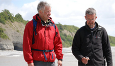
This eight mile linear walk took Derek on a trip down memory lane past many of his old haunts in Barry, along the coast to Porthkerry Country Park and mainland Wales' most southerly location - Rhoose Point.
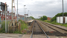
1. Start: Barry Docks train station
N 51.40222, W -3.26221
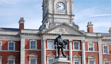
The walk begins at the train station near the Barry Docks Offices where we took a quick look at the statue of David Davies.
David Davies statue
David Davies was a Welsh industrialist and Liberal politician who sat in the House of Commons between 1874 and 1886 and was responsible for the construction of the docks at Barry.
The Barry Island peninsula was an island until the 1880s when it was linked to the mainland as the town of Barry expanded.
This was partly due to the opening of Barry Dock by the Barry Railway Company.
David Davies subsequently became very rich and his grand daughters who inherited much of his wealth, collected many valuable paintings by French impressionist painters which now reside in the National Museum of Cardiff.
2. Waterfront walk
N 51.40008, W -3.26690
From here we crossed over the busy Ffordd y Mileniwm road and turned left onto the new waterfront development with its wooden clad housing, flats and views over the water.
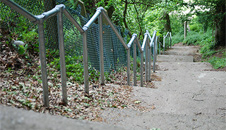
Following the road up, we turned left at the roundabout, passing through a tall yellow/black striped security gate along Powell Duffryn Way and up some steep steps to Clive Road.
From here walk the length of Clive Road heading east and turning right at the end of the street onto Clive Place and then along Plymouth road briefly before turning left on Friar's Road.
Here we stopped at a park above the harbour and met up with our first guide for the walk, Andy Hinton.
3. St Baruc's Chapel
N 51.39225, W -3.267139
The nearby St Baruc's Chapel is tucked away in a fenced off shady, wooded area and has an interesting tale behind it. St Baruc apparently drowned when his boat overturned on a trip back from Flat Holm Island.
His body washed ashore here and he was buried up on the headland where pilgrims subsequently began visiting in large numbers in Medieval times.
It's been suggested that Barry takes its name from Baruc who was actually an Irishman and Patron Saint of Cork but the jury is still out on that one.
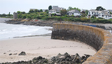
4. Jackson's Bay
N 51.39255, W -3.26429
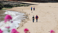
Heading north east we followed the trail down past Barry Yacht Club and along the pristine and golden sands of Jackson's Bay (where you'll find public toilets) to the concrete walkway on the other side of the beach.
This secluded beach must be one of Barry's best kept secrets, with its golden sands, sheltered aspect, pleasant views and lack of people.
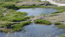
There's some interesting geology along this stretch of the walk - as you reach the path, you'll notice freshwater pools to your right on the ground.
These have been caused by water being washed down from natural springs above the cliffs and wearing away holes in the softer rocks below.
Walking along the concrete path you'll be rewarded with blustery sea views across to North Devon and the islands of Flat Holm and Steep Holm in the Bristol Channel.
5. The Promenade
N 51.38775, W -3.26544
Continue along the concrete footpath above the rocks on the far side of Jackson's Bay past the Coastguard look-out station at Nell's Point, and along to Barry Island's promenade.
The last Butlin's holiday camp was built on Nell's Point on a 45 acre site. The camp contained over 800 chalets and could accommodate nearly 5000 people.
It closed down in 1996 and the site was eventually demolished to make way for housing and a recreational area.
6. Barry Island Beach
N 51.39033, W -3.27421
Barry Island fun fair is renowned in Wales for its kiss-me-quick-atmosphere, fair rides, cafes and arcades.
The peninsula was actually an island until the 1880s when it was linked to the mainland as the town of Barry expanded.
Derek couldn't resist calling in at Marco's Café which featured regularly in the BBC One comedy series, Gavin and Stacey.
Keep an eye out for cardboard cut-outs of the stars and you can even get a guided tour of the locations"> featured in the series.
At the western end of the beach, follow the path leading up a lane towards the old harbour. Alternatively you can take a short detour and continue along the coast to Friar's Point if you fancy a look.
7. Looking towards Friar's Point
N 51.38595, W -3.27939
The headland here is a Special Site of Scientific Interest (SSSI) and is one of the best examples of calcareous, cowslip dominated hay meadow in South East Wales.
The site also provides habitat for a variety of invertebrates including bees, hoverflies, butterflies, grasshoppers and other insects.
The headland is also home to a Medieval pillow mound (rocky ground converted for rabbit farming) where rabbits were kept and bred as an important food source.
Near a ships mast (art installation) is an impressive old house, which was Barry's first hotel, the Marine Hotel: N 51.38954, W -3.28130 which was taken over by the army during WW2 but is now a private dwelling.
Walk to the end of the track and turn right following the path to the old harbour which flourished with exports during the 16th and 17th century.
Trade to the port gradually died out once the new causeway road was built linking Barry Island with the mainland in 1896.
Our next destination is Watch Tower Bay a few hundred yards opposite, but to get there you need to walk right around the old harbour.
8. Crossing the causeway
N 51.39223, W -3.27652
Walk along the side of the old harbour, through the car parking area, up steps beside the Harbour Road bridge and across the causeway (A4055).
Turn left at The Parade, then left again into Cold Knap Way and down the footpath past an old thatched farmhouse.
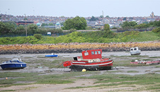
9. Watch Tower Bay
N 51.38876, W -3.28961
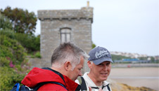
On the left you'll see the old watch tower which once marked the entrance to this busy port and was also used to store signal rockets.
10. Barry Lido
N 51.38813, W -3.29130
From here we walked across the site of the old Barry Lido where Derek once swam as a boy but which was later demolished and landscaped.
Turn left up the steps and walk along the promenade. The ornamental lake here is built in the shape of a harp which you can spot from a plane when flying into Cardiff Airport.
11. Cold Knap
N 51.38807 W -3.29291
This pebble beach has always been popular with sun seekers in summer and fishermen during winter and you can find remains of a large Roman building dating from 290 AD on the bank behind the Knap car park.
The pebble beach extends right alongside the promenade from the Lido. At the car park entrance (Knap Car Terrace), N 51.39003, W -3.29596, bear right and follow a track leading up in front of the houses and flats on the hillside for 200 metres.
12. Heading towards the Golden Steps
N 51.39003, W -3.29596
Continue steeply up through the field to the top and keep left for around 800 metres with Marine Drive road on your right.
At the far end you'll arrive at a small entrance way, leading you towards the Golden Steps and Porthkerry Country Park.
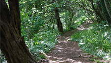
13. The Golden Steps
N 51.39330, W -3.30789
The woodland walk eventually brings you to the Golden Steps which are not golden at all but were put here by Lord Romilly. Local stories suggest that he laid a gold sovereign under the foundations during its construction.
Here you'll find the rare purple gromwell, white wood anemone and wealth of wildlife including adders, woodpeckers and bats. You can learn more about these on an information board by the steps.
Along the way we also spotted a submarine chugging up the Bristol channel, complete with crew on deck! Nearing the park, a peregrine falcon swooped low over the trees.
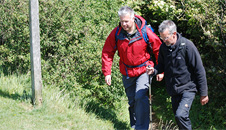
Our guide from Porthkerry Country Park was Warden, Rob Pritchard who took us the rest of the way to Rhoose Point.
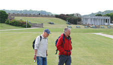
14. Porthkerry Country Park
N 51.39215, W -3.31392
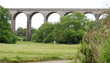
Porthkerry Country Park is a lovely park overlooked by an impressive railway viaduct, built in the 1890s to carry coal to Barry Docks.
The Romilly family who worked the land as a country estate sold it to the local council in 1929 and it's been a public park ever since.
At the bottom of the Golden Steps head off along the top of the beach in a south westerly direction for around 300 metres until you come to a waymarker signposted Millennium Coastal Path.
Bear right and head up a winding track leading you through pretty deciduous woodland until you exit at the bottom of a field near the airport.
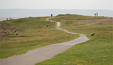
15. Bulwarks Camp
N 51.38880, W -3.32164
This field is actually the site of a fairly substantial Iron Age settlement known as the Bulwarks Camp but other than a slight rise in the field, there's not much left of it nowadays.
You will spot plenty of planes overhead here too as the route passes directly underneath the flight path for Cardiff International Airport.
The defended camp was probably occupied between 2000 B.C - 75 A.D before the Romans arrived in South Wales.
16. Porthkerry Caravan Park
N 51.388474, W -3.3236539
Follow a grassy track which cuts across the field diagonally in a north-westerly direction towards the caravan park. As you enter the caravan park, keep left and follow the road running parallel with the sea.
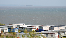
Fans of the BBC One comedy, Gavin and Stacey may recognise some of the static caravans here, as they were used for filming Nessa's home, during the series.
After approximately 350 metres, turn right towards Lower Quarry on the road skirting the caravan park and follow it around until facing the sea, before it drops down the road to Lower Quarry.
At the end of the road are some nice views looking back over the Knap at Barry and the Bristol Channel beyond.
17. Road to Rhoose Point
51.38547, -3.33046
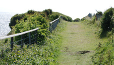
Turn right onto a small footpath running parallel to the road you've just walked before taking you left into a field towards the coastal path.
Stay on the path along this stretch as the cliffs although very beautiful to look at are very dangerous and prone to rock slides and falls.
After 500 metres or so you'll arrive at some steep steps down.
At the bottom you'll see a short track leading off to a pebble beach on your left, a slight detour that takes you closer to the waters edge if you wish to have a look.
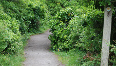
Return to the main trail and climb up the steps and onto a long and narrow sheltered pathway, edged by hedgerows and wild flowers on either side.
Follow this path straight down for a further 500 metres towards Rhoose Point. On your right you'll see some man-made pools left over from the old stone quarry.
These days the pools are a wildlife sanctuary and support a whole range of birds, mammals, plants and insects and it's incredible to see what has grown up here out of nothing since the quarry closed in 2000.
Stone circles and shapes
At N 51.38164, W -3.34362
Approaching the point, you may spot what appear to be strange stone circles in the ground here. Rest assured, no alien activity has taken place though - these symbols were placed here by the company that helped reclaim and manage the site.
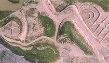
There are plenty more shapes too, including a compass and various snail-shaped squiggles, which can only be properly appreciated from the air, so take a look at the area on Google or Bing maps.
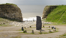
18. Rhoose Point
N 51.38526, W -3.33650
Rhoose Point (Trwyn y Rhws in Welsh) is the most southerly point in mainland Wales.
As you approach the impressive stone circle and upright four metre obelisk you'll spot equally impressive, natural cliffs to your left, which look as if they're guarding an ancient portal into the underworld.
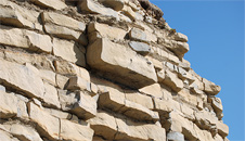
The layered limestone cliffs here are spectacular and incredibly photogenic in late afternoon sun. The area is also littered with fossils and huge, round, pebble shaped stones.
Take care if you venture onto the beach as the ground is uneven and it's best to avoid standing too near the cliffs edges as they can be prone to rock falls.
If you walk up past the stone circle onto the cliff top, you'll get nice views along the coast to Aberthaw and it's also worth taking time to explore the lagoon here which is surrounded by wild orchids and other rare plants.
19. End of the walk: Rhoose train station
N 51.38526, W -3.33650
Continue along the coastal path for a few hundred metres then turn right, uphill along a field boundary to a railway crossing besides Rhoose railway station, off Torbay Terrace to return to Barry and Cardiff.
See Also
Pictures from the walk

Barry to Rhoose Point
Take a look at photos taken during the Barry to Rhoose walk.
Weatherman walking map
Explore Wales
Follow in Derek's footsteps as he walks through stunning locations in Wales.

Your current UK location is Cardiff
Multiple locations have been found.
Please refine your location by choosing a place name from the list.
Sorry, no results were found. Please try again.
| Sunday | Monday | Tuesday | |
|---|---|---|---|
| Conditions |  sunny |  cloudy |  sunny intervals |
| Max Temperature | Max: 16°C | Max: 13°C | Max: 13°C |
| Min Temparature | Min: 10°C | Min: 8°C | Min: 6°C |