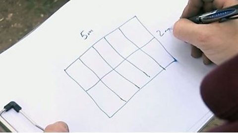
Kitchen designer: As a kitchen designer, plans are the heart of our business, so what we do is we go into our customer's property and actually plan out the whole kitchen, making sure that we've taken reference where the doors are, where the windows are, and that gives us a platform to actually design the kitchen that the customer wants.
Male: You wouldn't have a piece of paper the size of the room and go out to somewhere, B&Q and say, here's my thing, I want that.
Builder: It's to make it easier to work with because you've only got a smaller piece of paper and you can see clearly what needs to be done and what your measurements are.
Bus driver: If they're doing roadworks and it's going to be an extended roadworks, they're going to be on for say, a month or two months they'll produce a map for Manchester showing you where your new diversion is going to be.
Gardener: I've got a plan to chance the position and size of every feature in the garden.
Most garden plans are on a scale of 50:1, so this pond is six centimetres on the plan and a scale of 1:50, which means that in real life it's 300 centimetres or three meters.
Constructing the garden according to the plan is essential because that's what the client and the designer have agreed.
You use plans to make accurate scale drawings of rooms or places. Maps are helpful for finding your way around a location.
Quick tips for tutors
Maps and plans includes:
- Understanding different types of maps, diagrams and plans
- The different scale and labels on maps and plans
- Learning how to draw a plan and how to arrange items on a plan
- Calculating the distance between points on a map using scale
- Understanding how measurements are represented in a plan of a room
- Calculating distance measurements represented in maps and room plans
Downloadable Factsheets
Entry 3 - Diagrams and maps
Introductory explanation on diagrams, maps and plans.
Entry 3 - Plans: garden example
An example of how to draw and label a plan, in this case a garden plan.
Level 1 - Maps and scale
An explanation of how the scale of a map works and how to work out the distance between two points.
Level 1 - Plans
This task shows how you can use a room plan drawn to scale to see how furniture could be arranged in a room.
Downloadable Worksheets
Entry 3 - Maps exercise
A fill in the gap exercise to help with map reading and working out distances using the map's scale.
Entry 3 - Reading a simple plan
Questions to test your plan reading skills.
Level 1 - Garden plans
Questions to test your plan reading skills as well as a task to develop some basic plan drawing skills.