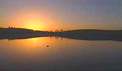
Tidal Treasures - Article submitted by Stan Howes - Nov '05 It was half-eight on a Sunday morning in September, dawn light lingering over Greyabbey Bay. Sitting in the car I watched birds flicker across the sand flats and the watery channels left by the tide. 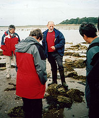 | Tom McErlean (centre)
explains stone fish trap design |
A bearded middle-aged man in a blue anorak got out of his car and approached. ‘Are you going on the archaeology walk this morning?’ he said genially. ‘I’m Tom McErlean.’ We shook hands. Tom, from the Centre for Marine Archaeology at the University of Ulster, is one of the contributors to Strangford Lough, a hefty hardback tome published by Blackstaff Press on the five-year long archaeological survey of the foreshore of the lough, which began in 1995. He instantly came across as friendly and enthusiastic, terrifically knowledgeable and bursting to talk about his favourite subject. During the survey over 680 sites were discovered shedding a new and surprising light on the lough’s history, from the tidal mills at Nendrum Monastery to the Neolithic logboat stumbled on in Greyabbey Bay. It was the logboat and other foreshore features that had me up at such a painfully early hour. When fifteen minutes had elapsed, about a dozen people had shown up for the walk, which had been organised by the National Trust. Tom seemed happy. He thought smaller groups were better for everyone could hear what he was saying and he didn’t have to repeat himself. He began by giving an impromptu lecture on the history of Strangford Lough: the fact the lough was once dry land, the rising sea level following the Ice Age, drumlin islands, hunter gatherer communities giving way to agricultural ones, the shell middens, the exploitation of the foreshore particularly under monastic control, the fish traps and later the seaweed harvesting, the kelp trade and its decline. In the space of ten minutes he had brought us from prehistory to the twentieth century. My mind was whirling with facts! 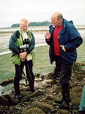 | | David Thompson of the National Trust looks on as Tom McErlean reveals the secrets of the foreshore |
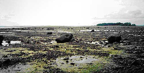
As the day brightened and sunlight filled the sky we set off in walking boots or wellingtons across the sand flats spread with heaps of shells and rocky pladdies. The foreshore, while still very wet and the sand and mud soft in places, was starting to give up its archaeological treasures. The most obvious were the stone fish traps: a long line of boulders usually in a V or crescent shape built similarly to drystone walls. Some are 200 metres in length and one as long as 350 metres. When in use the traps would have been 1-1.5 metres high. The object was to catch fish on the ebb tide. In short, the fish would be stranded in the shallow pool behind the wall of the trap allowing them to be easily caught. The catch would have been mainly herring, mullet and mackerel. The location of the traps also suggests an accurate knowledge by the builders of the movement of fish within the lough. The stone traps date from the thirteenth century when the Cistercians established a monastery at Greyabbey and put the fishery in the bay on a more commercial footing. Dried salted fish was always in demand to feed English armies. (One recently restored stone fish trap produced a catch of mullet). The wooden traps date from the seventh century A.D. to the coming of the Cistercians and function essentially in the same way although they would have needed more maintenance. The pointy pole ends are visible at low tide. Although we were not to see them on our walk, shell middens were another feature that turned up during the survey scattered around the edges of the lough. For thousands of years shellfish have been an important food source: cockle, limpet, mussel, periwinkle, whelk and native oyster. 27 middens were found and recorded, some dating back to the Mesolithic period: 7000 to 4000BC. The native oyster has seriously declined and there is a project afoot to reintroduce it. Tom pointed out stumps of old trees protruding above the sand. These blackened remains have been dated to 6,700 BC. It was in this area that we had hoped to see one of those rare finds: a 5,000-year-old logboat. However, it was not to be; tide and sand had re-buried it. To remove wood of this antiquity results in almost immediate decay. Logboats discovered in the past have been preserved, but at considerable expense. Leaving it in situ was not only a cheaper solution, but for those who would be lucky enough to see it there, it would provide a more vivid historical and geographical context than in a museum. Close to one of the islands, our attention was drawn to a kelp grid: a regular arrangement of rows of stones on which seaweed is grown and harvested. Seaweed needs a rocky base to attach its roots; it will not grow on sandy shores. In the eighteenth century there was a thriving kelp industry. When burned, kelp or seaweed produces a soda ash (soda carbonate) which was used in the manufacture of glass and soap and in the bleaching of linen. Unfortunately for local workers, in the 1820s the prices for kelp plummeted, when an alternative supply was found in salt and barilla. The remains of a kelp house and kilns can be seen on nearby Chapel Island. In the nineteenth century seaweed was discovered to contain iodine, but this was never produced in significant quantities. | Strangford Lough - full of Tidal Treasures |
It was nearing midday when we had seen all that there was to be seen on the foreshore. Throughout the walk Tom had invited questions and was never stumped for an answer. In fact, he seemed to thrill at the challenge. What was striking was his wide-ranging knowledge that was clearly born out of an insatiable curiosity and imaginative excitement about the past and those who had gone before and who had left their enduring mark, in the form of these archaeological monuments, on the landscape. Looking across the foreshore I was surprised to see how far we had travelled both in distance and in historical perspective. Further south towards the narrows, I could see the water glistening under the warm sun and thought this beautiful scene would have changed little since one of the Cistercian monks, working a fish trap, might have straightened a tired back and gazed around in wordless wonder. YOUR RESPONSES William A Moore - Dec '07
I was born in N.Ireland but spent most of my life in England, mainly in East Anglia. Now I'm trying to catch up with the hitory of the land of my birth. I have seen these stones in uniform layout, wondering how long they have been there. I have asked many people mainly locals (if you can find them) as there are a lot of "Blow Ins "! Unfortunately I got no help from anyone, I think they thought I was away in the head wanting to know about oul stones.
Alas help arrived to-day 23/12/2007, by way of a beautiful book. Called Strangford, Portrait of an Irish Lough. By Alain Le Garsmeur and Ian Hill.
Then I read this article, this is an answer to all my questions. I'm really glad that I'm not the only person around that is mad about stones. This a very good article, I live in Portavogie, I see something new every day when I look at the lough. I look in wonder that all the water covering the lough passes through that tiney gap that seperates Strangford from Portaferry. Stephen Ashe - Aug'06
Just back from Kircubbin collecting cockles and mussles beautiful place getting harder to find them.It seemed easier to get them when I was a kid.
Lynda Croft - April '06
Wonderful stuff, you bring it to life with your words. |


 print version