Costing a princely £28,000, the canal became a major thoroughfare for the town, adding to the wealth generated from the wool trade. It was over eleven miles in length, extending from Louth Riverhead to Tetney and eight locks were incorporated to overcome the forty six feet differential in levels involved. Trade through the canal was brisk and there were regular sailings to London and Hull and other local ports. In 1920 disaster struck the prosperous town when the river and canal flooded, destroying large areas of Louth and killing 23 people. The waterway finally closed in 1924, after a period of decline following the opening of the railway. The 18th century wool warehouse at the head of the canal is now a restaurant and public meeting place and houses an excellent display of the canal. Although the waterway itself is no longer navigable, the towpaths have been restored and make a fine walk out of town. 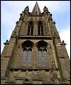
St James' Church |
Adorning the Louth skyline is the parish church of St James. With its 300 foot tower standing high above the town, it is the most famous landmark in the immediate area. Other historic buildings include a number of coaching inns, as well as fine period houses in Westgate and Upgate. The town sits on the Greenwich meridian and a small plaque in Eastgate marks the line.  Take a pop-up tour of Louth Take a pop-up tour of Louth
|