7 November 2014 |

| |
BBC Homepage | |||
Contact Us | |||
About WorcestershireYou are in: Hereford and Worcester > About Worcestershire > Worcester the way it was 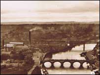 Old picture of Worcester Worcester the way it wasThese old photos, taken from the top of Worcester cathedral, show the city in the early 20th century. These old pictures of Worcester, taken from the top of the Cathedral tower, were originally used in postcards. They are used with kind permission on the Malvern Industrial Archaeology Circle (MIAC), and feature on their web page, detailing the history of the railways in Worcestershire: Malvern Industrial Archaeology CircleThe BBC is not responsible for the content of external websites 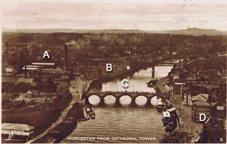 Lettering explained below A: Worcester Power Station: Built in 1903, this building was demolished in 1942, and replaced with a much bigger building. This stood on the site until 1979, and all that remains of it now is a pumping station on the side of the river, just past the Hylton Road/Tybridge Street traffic lights. The area where the power station stood is now a park. B: Hylton Road. The area where Hylton Road now runs is built up in this photo. C: The main river bridge over the River Severn is narrower in this photo than it is today. The original bridge was built in 1781 by the famous engineer John Gwynne. By 1841 the traffic had increased considerably, and the engineer E. Leader Williams designed a cast iron footpath on each side, for pedestrians to use, and an iron ballustrade. The bridge was widened in the 1930s. D: Some of the buildings seen on South Quay in Worcester still survive. The large warehouse has now been converted into housing and a restaurant. At one time this area contained some of the worst slums in the city, which were demolished in the 1920's 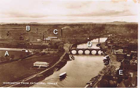 Lettering explained below A: New Road cricket ground - before the stands were built. The ground was originally three sheep fields, owned by the Dean and Chapter of Worcester cathedral. Worcestershire began playing there in 1899. B: Dines Green, in St Johns, now a large housing estate. The church visible on the left is St Clements. C: The Worcester to Hereford railway line originally crossed the River Severn on an elegant three span bridge, built in 1859. This bridge was replaced by the current two span bridge in 1905. The viaduct is 935 yards long and contains 68 brick arches. D: The River Severn was still very much a "working" river - with goods being carried upstream and downstream from Worcester. E: There were many more building around the Cathedral, including The Dent and Allcroft Glove factory, on South Quay, demolished in the 1960's. 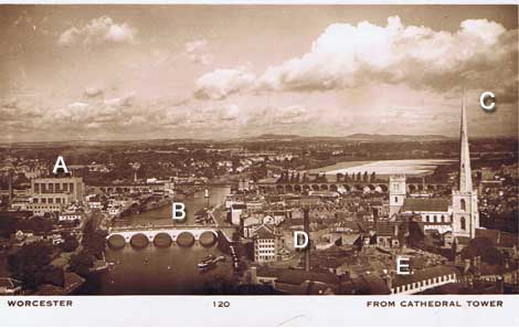 Lettering explained below A: The Power Station built in 1942, which dominated the St John's side of the river until it was demolished in the 1970's. The power station had its own light guage railway, and there were sidings on the south side of the Worcester to Hereford railway line, shortly before Henwick station. B: The widened bridge over the River Severn dating from the 1930's. C: St Andrew's church was demolished during the 1940's, although the 18th century spire was retained as the "Glover's Needle". D: The chimney from the Dent and Allcroft Glove factory. The factory complex was demolished during the early 1960's, to make way for the Worcester Technical College buildings. E: More of the buildings demolished to make way for the Technical College. last updated: 17/01/2008 at 15:39 You are in: Hereford and Worcester > About Worcestershire > Worcester the way it was Some the most interesting buildings in the two counties |
About the BBC | Help | Terms of Use | Privacy & Cookies Policy |
